
Topografische Karte Dillon
Interaktive Karte
Klicken Sie auf die Karte, um die Höhe anzuzeigen.
Über diese Karte
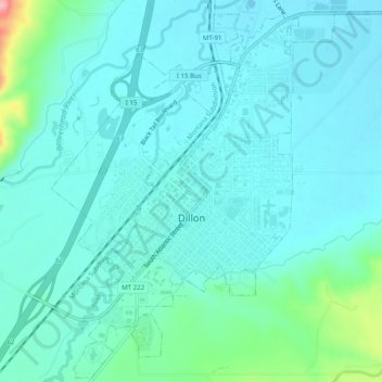
Name: Topografische Karte Dillon, Höhe, Relief.
Ort: Dillon, Beaverhead County, Montana, United States (45.19960 -112.65274 45.23354 -112.60351)
Durchschnittliche Höhe: 1.562 m
Minimale Höhe: 1.541 m
Maximale Höhe: 1.669 m
Dillon is located at 45°12′57″N 112°38′3″W / 45.21583°N 112.63417°W / 45.21583; -112.63417 (45.215735, -112.634055), approximately 40 miles (64 km) east of the Continental Divide. It lies at an elevation of 5,102 feet (1,555 m).
Andere topografische Karten
Klicken Sie auf eine Karte, um ihre Topografie, ihre Höhe und ihr Relief anzuzeigen.
Polaris
United States > Montana > Beaverhead County
Polaris, Beaverhead County, Montana, United States
Durchschnittliche Höhe: 2.016 m
Jackson
United States > Montana > Beaverhead County
Jackson, Beaverhead County, Montana, 59736, United States
Durchschnittliche Höhe: 1.995 m
Monida
United States > Montana > Beaverhead County
Monida, Beaverhead County, Montana, United States
Durchschnittliche Höhe: 2.111 m