
Topografische Karte McCaysville
Interaktive Karte
Klicken Sie auf die Karte, um die Höhe anzuzeigen.
Über diese Karte
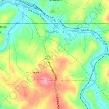
Name: Topografische Karte McCaysville, Höhe, Relief.
Ort: McCaysville, Fannin County, Georgia, United States (34.97250 -84.38621 34.98815 -84.35309)
Durchschnittliche Höhe: 484 m
Minimale Höhe: 437 m
Maximale Höhe: 548 m
McCaysville's weather is temperate due to its elevation and location in the southern Appalachians. Summers are warm with average highs in the middle 80s and lows in the lower 60s. Winters are cool with average highs in the 40s and average lows in the 20s. Rainfall is abundant with the yearly average approaching 67 inches and occurring on 127 days. Snowfall usually occurs on several occasions during the winter months and can range from a light dusting to the occasional significant storm. The most significant snow storm to hit the area occurred March 12–14, 1993, when the area received approximately 40 inches in what eastern seaboard residents often refer to as "the storm of the century". The average first frost occurs in mid-October with the average last frost occurring in late April.
Andere topografische Karten
Klicken Sie auf eine Karte, um ihre Topografie, ihre Höhe und ihr Relief anzuzeigen.
Blue Ridge
United States > Georgia > Fannin County
Blue Ridge, Fannin County, Georgia, United States
Durchschnittliche Höhe: 535 m
Wilscot
United States > Georgia > Fannin County
Wilscot, Fannin County, Georgia, United States
Durchschnittliche Höhe: 614 m
Aska
United States > Georgia > Fannin County
Aska, Fannin County, Georgia, United States
Durchschnittliche Höhe: 629 m
Greens Mill
United States > Georgia > Fannin County
Greens Mill, Fannin County, Georgia, 30513, United States
Durchschnittliche Höhe: 566 m
Dial
United States > Georgia > Fannin County
Dial, Fannin County, Georgia, United States
Durchschnittliche Höhe: 612 m
Colwell
United States > Georgia > Fannin County
Colwell, Fannin County, Georgia, United States
Durchschnittliche Höhe: 630 m
Higdon
United States > Georgia > Fannin County
Higdon, Fannin County, Georgia, 30541, United States
Durchschnittliche Höhe: 595 m
Lake Blue Ridge
United States > Georgia > Fannin County > Morganton
Lake Blue Ridge, Morganton, Fannin County, Georgia, United States
Durchschnittliche Höhe: 572 m
Cordell Mountain
United States > Georgia > Fannin County
Cordell Mountain, Fannin County, Georgia, 30559, United States
Durchschnittliche Höhe: 601 m
Springer Mountain
United States > Georgia > Fannin County
Springer Mountain, Fannin County, Georgia, United States
Durchschnittliche Höhe: 941 m
Ocoee River
United States > Georgia > Fannin County
Ocoee River, Fannin County, East Tennessee, Georgia, 30572, United States
Durchschnittliche Höhe: 579 m
Morganton
United States > Georgia > Fannin County
Morganton, Fannin County, Georgia, United States
Durchschnittliche Höhe: 538 m
Mineral Bluff
United States > Georgia > Fannin County
Mineral Bluff, Fannin County, Georgia, 30559, United States
Durchschnittliche Höhe: 516 m
Kyle
United States > Georgia > Fannin County
Kyle, Fannin County, Georgia, 30555, United States
Durchschnittliche Höhe: 508 m
Epworth
United States > Georgia > Fannin County > Epworth
Epworth, Fannin County, Georgia, 30555, United States
Durchschnittliche Höhe: 524 m
Loving
United States > Georgia > Fannin County > Loving
Loving, Fannin County, Georgia, 30560, United States
Durchschnittliche Höhe: 577 m