
Topografische Karte Springer Mountain
Interaktive Karte
Klicken Sie auf die Karte, um die Höhe anzuzeigen.
Über diese Karte
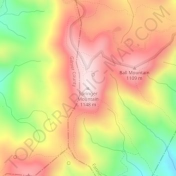
Name: Topografische Karte Springer Mountain, Höhe, Relief.
Ort: Springer Mountain, Fannin County, Georgia, United States (34.62660 -84.19358 34.62670 -84.19348)
Durchschnittliche Höhe: 941 m
Minimale Höhe: 670 m
Maximale Höhe: 1.141 m
Springer Mountain is a mountain located in the Chattahoochee National Forest on the border of Fannin and Gilmer counties. Located in the Blue Ridge Mountains in northern Georgia, the mountain has an elevation of about 3,782 feet (1,153 m). Springer Mountain serves as the southern terminus for the Appalachian and Benton MacKaye trails.
Andere topografische Karten
Klicken Sie auf eine Karte, um ihre Topografie, ihre Höhe und ihr Relief anzuzeigen.
Blue Ridge
United States > Georgia > Fannin County
Blue Ridge, Fannin County, Georgia, United States
Durchschnittliche Höhe: 535 m
Wilscot
United States > Georgia > Fannin County
Wilscot, Fannin County, Georgia, United States
Durchschnittliche Höhe: 614 m
Aska
United States > Georgia > Fannin County
Aska, Fannin County, Georgia, United States
Durchschnittliche Höhe: 629 m
Greens Mill
United States > Georgia > Fannin County
Greens Mill, Fannin County, Georgia, 30513, United States
Durchschnittliche Höhe: 566 m
Dial
United States > Georgia > Fannin County
Dial, Fannin County, Georgia, United States
Durchschnittliche Höhe: 612 m
Colwell
United States > Georgia > Fannin County
Colwell, Fannin County, Georgia, United States
Durchschnittliche Höhe: 630 m
Higdon
United States > Georgia > Fannin County
Higdon, Fannin County, Georgia, 30541, United States
Durchschnittliche Höhe: 595 m
Lake Blue Ridge
United States > Georgia > Fannin County > Morganton
Lake Blue Ridge, Morganton, Fannin County, Georgia, United States
Durchschnittliche Höhe: 572 m
Cordell Mountain
United States > Georgia > Fannin County
Cordell Mountain, Fannin County, Georgia, 30559, United States
Durchschnittliche Höhe: 601 m
Ocoee River
United States > Georgia > Fannin County
Ocoee River, Fannin County, East Tennessee, Georgia, 30572, United States
Durchschnittliche Höhe: 579 m
McCaysville
United States > Georgia > Fannin County
McCaysville, Fannin County, Georgia, United States
Durchschnittliche Höhe: 484 m
Morganton
United States > Georgia > Fannin County
Morganton, Fannin County, Georgia, United States
Durchschnittliche Höhe: 538 m
Mineral Bluff
United States > Georgia > Fannin County
Mineral Bluff, Fannin County, Georgia, 30559, United States
Durchschnittliche Höhe: 516 m
Kyle
United States > Georgia > Fannin County
Kyle, Fannin County, Georgia, 30555, United States
Durchschnittliche Höhe: 508 m
Epworth
United States > Georgia > Fannin County > Epworth
Epworth, Fannin County, Georgia, 30555, United States
Durchschnittliche Höhe: 524 m
Loving
United States > Georgia > Fannin County > Loving
Loving, Fannin County, Georgia, 30560, United States
Durchschnittliche Höhe: 577 m