
Topografische Karte Lake County
Interaktive Karte
Klicken Sie auf die Karte, um die Höhe anzuzeigen.
Über diese Karte
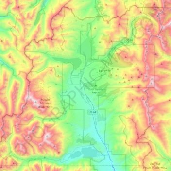
Name: Topografische Karte Lake County, Höhe, Relief.
Ort: Lake County, Colorado, United States (39.05652 -106.58674 39.38371 -106.13586)
Durchschnittliche Höhe: 3.398 m
Minimale Höhe: 2.739 m
Maximale Höhe: 4.388 m
Lake County is one of 64 counties in the U.S. state of Colorado. As of the 2010 census, the population was 7,310. The county seat and the only municipality in the county is Leadville. The highest natural point in Colorado and the entire Rocky Mountains is the summit of Mount Elbert in Lake County at 14,440 feet (4401.2 meters) elevation.
Andere topografische Karten
Klicken Sie auf eine Karte, um ihre Topografie, ihre Höhe und ihr Relief anzuzeigen.
Mount Sherman
United States > Colorado > Lake County
Mount Sherman, Lake County, Colorado, United States
Durchschnittliche Höhe: 3.989 m
Leadville
United States > Colorado > Lake County
Leadville, Lake County, Colorado, 80461, United States
Durchschnittliche Höhe: 3.106 m
Leadville
United States > Colorado > Lake County
Leadville, Lake County, Colorado, 80461, United States
Durchschnittliche Höhe: 3.106 m
Mount Elbert
United States > Colorado > Lake County
Mount Elbert, Lake County, Colorado, United States
Durchschnittliche Höhe: 3.958 m