
Topografische Karte Leadville
Interaktive Karte
Klicken Sie auf die Karte, um die Höhe anzuzeigen.
Über diese Karte
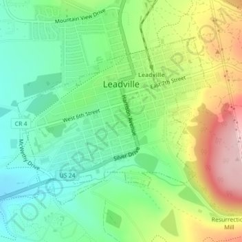
Name: Topografische Karte Leadville, Höhe, Relief.
Ort: Leadville, Lake County, Colorado, 80461, United States (39.23730 -106.30754 39.25598 -106.27958)
Durchschnittliche Höhe: 3.106 m
Minimale Höhe: 3.023 m
Maximale Höhe: 3.247 m
The City of Leadville is a statutory city that is the county seat, the most populous community, and the only incorporated municipality in Lake County, Colorado, United States. The city population was 2,602 at the 2010 census and an estimated 2,762 in 2018. It is situated at an elevation of 10,152 feet (3,094 m). Leadville is the highest incorporated city in the United States and it is surrounded by two of the tallest 14,000 foot peaks in the state.
Andere topografische Karten
Klicken Sie auf eine Karte, um ihre Topografie, ihre Höhe und ihr Relief anzuzeigen.
Mount Sherman
United States > Colorado > Lake County
Mount Sherman, Lake County, Colorado, United States
Durchschnittliche Höhe: 3.989 m
Leadville
United States > Colorado > Lake County
Leadville, Lake County, Colorado, 80461, United States
Durchschnittliche Höhe: 3.106 m
Mount Elbert
United States > Colorado > Lake County
Mount Elbert, Lake County, Colorado, United States
Durchschnittliche Höhe: 3.958 m
Lake County
United States > Colorado > Lake County
Lake County, Colorado, United States
Durchschnittliche Höhe: 3.398 m