
Topografische Karte Mzamba River
Interaktive Karte
Klicken Sie auf die Karte, um die Höhe anzuzeigen.
Über diese Karte
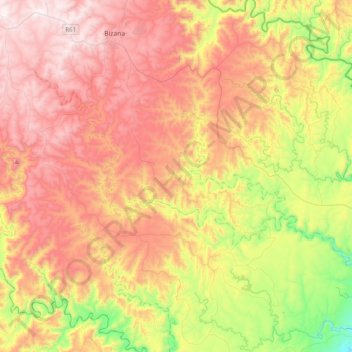
Name: Topografische Karte Mzamba River, Höhe, Relief.
Durchschnittliche Höhe: 530 m
Minimale Höhe: 7 m
Maximale Höhe: 1.011 m
Andere topografische Karten
Klicken Sie auf eine Karte, um ihre Topografie, ihre Höhe und ihr Relief anzuzeigen.
Maluti
South Africa > Eastern Cape > Alfred Nzo District Municipality > Matatiele Local Municipality
Maluti, Matatiele Local Municipality, Alfred Nzo District Municipality, Eastern Cape, South Africa
Durchschnittliche Höhe: 1.487 m
Ntabankulu Ward 3
South Africa > Eastern Cape > Alfred Nzo District Municipality > Ntabankulu Local Municipality
Ntabankulu Ward 3, Ntabankulu Local Municipality, Alfred Nzo District Municipality, Eastern Cape, South Africa
Durchschnittliche Höhe: 677 m
Ebenezer
South Africa > Eastern Cape > Alfred Nzo District Municipality > Mbizana Local Municipality
Ebenezer, Mbizana Ward 24, Mbizana Local Municipality, Alfred Nzo District Municipality, Eastern Cape, South Africa
Durchschnittliche Höhe: 109 m
Tina River
South Africa > Eastern Cape > Alfred Nzo District Municipality > Umzimvubu Local Municipality
Tina River, Umzimvubu Local Municipality, Alfred Nzo District Municipality, Eastern Cape, South Africa
Durchschnittliche Höhe: 975 m
Cedarville
South Africa > Eastern Cape > Alfred Nzo District Municipality > Matatiele Local Municipality
Cedarville, Matatiele Local Municipality, Alfred Nzo District Municipality, Eastern Cape, South Africa
Durchschnittliche Höhe: 1.495 m
Matatiele
South Africa > Eastern Cape > Alfred Nzo District Municipality > Matatiele Local Municipality
Matatiele, Matatiele Local Municipality, Alfred Nzo District Municipality, Eastern Cape, 4470, South Africa
Durchschnittliche Höhe: 1.603 m
Cedarberg
South Africa > Eastern Cape > Alfred Nzo District Municipality > Matatiele Local Municipality
Cedarberg, Matatiele Local Municipality, Alfred Nzo District Municipality, Eastern Cape, South Africa
Durchschnittliche Höhe: 1.634 m
Mzamba River
South Africa > Eastern Cape > Alfred Nzo District Municipality > Mbizana Local Municipality
Mzamba River, Mbizana Ward 28, Mbizana Local Municipality, Alfred Nzo District Municipality, Eastern Cape, South Africa
Durchschnittliche Höhe: 31 m
Bizana
South Africa > Eastern Cape > Alfred Nzo District Municipality > Mbizana Local Municipality
Bizana, Mbizana Local Municipality, Alfred Nzo District Municipality, Eastern Cape, 4800, South Africa
Durchschnittliche Höhe: 823 m
KwaBhaca (Mount Frere)
South Africa > Eastern Cape > Alfred Nzo District Municipality > Umzimvubu Local Municipality
KwaBhaca (Mount Frere), Umzimvubu Local Municipality, Alfred Nzo District Municipality, Eastern Cape, South Africa
Durchschnittliche Höhe: 1.116 m
eMaXesibeni (Mount Ayliff)
South Africa > Eastern Cape > Alfred Nzo District Municipality > Umzimvubu Local Municipality
eMaXesibeni (Mount Ayliff), Umzimvubu Local Municipality, Alfred Nzo District Municipality, Eastern Cape, 4375, South Africa
Durchschnittliche Höhe: 1.128 m
Mbizana Local Municipality
South Africa > Eastern Cape > Alfred Nzo District Municipality
Mbizana Local Municipality, Alfred Nzo District Municipality, Eastern Cape, 4800, South Africa
Durchschnittliche Höhe: 635 m
Umzimvubu Local Municipality
South Africa > Eastern Cape > Alfred Nzo District Municipality
Umzimvubu Local Municipality, Alfred Nzo District Municipality, Eastern Cape, 4375, South Africa
Durchschnittliche Höhe: 1.255 m