
Topografische Karte Cle Elum
Interaktive Karte
Klicken Sie auf die Karte, um die Höhe anzuzeigen.
Über diese Karte
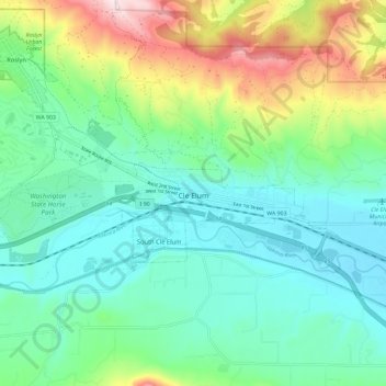
Name: Topografische Karte Cle Elum, Höhe, Relief.
Durchschnittliche Höhe: 697 m
Minimale Höhe: 561 m
Maximale Höhe: 1.058 m
Cle Elum was originally inhabited by the Kittitas band of the Yakama tribe. The tribe fished salmon, steelhead, and trout from the Yakima River. The Salmon la Sac trails in the northern area of the region were created by the Kittitas people and were used as layovers for journeys into the higher altitudes of the Cascade Range. In 1855, after the arrival of Catholic missionaries, and the passing through of settlers and coal miners on their way to the Puget Sound, a treaty resulted in the Yakamas ceding most of their land for a reservation in the lower Yakima Valley and guaranteed access to fish, including what would later be incorporated as Cle Elum. By 1859, the Kittitas had been forced to relocate to the Yakama Indian Reservation.
Andere topografische Karten
Klicken Sie auf eine Karte, um ihre Topografie, ihre Höhe und ihr Relief anzuzeigen.
Snoqualmie Pass
United States > Washington > Kittitas County
Snoqualmie Pass, Kittitas County, Washington, United States
Durchschnittliche Höhe: 955 m
Driftwood Acres
United States > Washington > Kittitas County
Driftwood Acres, Kittitas County, Washington, 98940, United States
Durchschnittliche Höhe: 788 m
Regal
United States > Washington > Kittitas County
Regal, Kittitas County, Washington, 98934, United States
Durchschnittliche Höhe: 491 m
Teanaway
United States > Washington > Kittitas County
Teanaway, Kittitas County, Washington, United States
Durchschnittliche Höhe: 592 m
French Cabin Basin
United States > Washington > Kittitas County
French Cabin Basin, Kittitas County, Washington, United States
Durchschnittliche Höhe: 1.400 m
Ellensburg
United States > Washington > Kittitas County > Ellensburg > Ellensburg
Ellensburg, Kittitas County, Washington, 98926, United States
Durchschnittliche Höhe: 485 m
South Cle Elum
United States > Washington > Kittitas County
South Cle Elum, Kittitas County, Washington, 98943, United States
Durchschnittliche Höhe: 603 m
Easton
United States > Washington > Kittitas County
Easton, Kittitas County, Washington, 98925, United States
Durchschnittliche Höhe: 742 m
Roslyn
United States > Washington > Kittitas County
Roslyn, Kittitas County, Washington, 98941, United States
Durchschnittliche Höhe: 742 m
Mary's Peak
United States > Washington > Kittitas County
Mary's Peak, Kittitas County, Washington, United States
Durchschnittliche Höhe: 1.717 m
Cle Elum
United States > Washington > Kittitas County > Cle Elum > Cle Elum
Cle Elum, Kittitas County, Washington, 98922, United States
Durchschnittliche Höhe: 697 m
Ellensburg
United States > Washington > Kittitas County
Ellensburg, Kittitas County, Washington, 98926, United States
Durchschnittliche Höhe: 480 m
Diamond Head
United States > Washington > Kittitas County
Diamond Head, Kittitas County, Washington, United States
Durchschnittliche Höhe: 1.571 m
The Ganges
United States > Washington > Kittitas County > Ellensburg
The Ganges, Ellensburg, Kittitas County, Washington, 98926, United States
Durchschnittliche Höhe: 488 m
Vantage
United States > Washington > Kittitas County > Vantage
Vantage, Kittitas County, Washington, United States
Durchschnittliche Höhe: 222 m
Thorp
United States > Washington > Kittitas County
Thorp, Kittitas County, Washington, United States
Durchschnittliche Höhe: 521 m
Alpine Lakes Wilderness
United States > Washington > Kittitas County
Alpine Lakes Wilderness, Kittitas County, Washington, United States
Durchschnittliche Höhe: 1.165 m