Geolokalisieren

Topografische Karte Mayer

Klicken Sie auf die Karte, um die Höhe anzuzeigen.

Über diese Karte

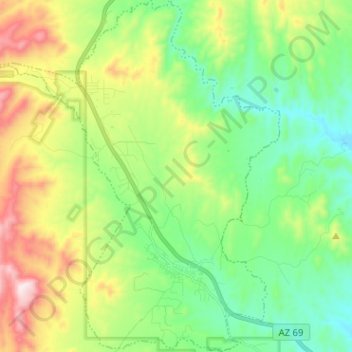
Name: Topografische Karte Mayer, Höhe, Relief.

Ort: Mayer, Yavapai County, Arizona, United States (34.37394 -112.30922 34.47878 -112.19937)

Durchschnittliche Höhe: 1.427 m

Minimale Höhe: 1.210 m

Maximale Höhe: 1.866 m

Andere topografische Karten

Klicken Sie auf eine Karte, um ihre Topografie, ihre Höhe und ihr Relief anzuzeigen.

Chino Valley

United States > Arizona > Yavapai County

The town is in north-central Arizona, on state Highway 89, 15 miles (24 km) north of Prescott and 35 miles (56 km) south of Ash Fork, which is on Interstate 40. Chino Valley is at an elevation of about 4,750 feet (1,450 m).

Durchschnittliche Höhe: 1.454 m

Paradise Acres

United States > Arizona > Yavapai County > Camp Verde

Durchschnittliche Höhe: 948 m

Williamson Valley Wash

United States > Arizona > Yavapai County

Durchschnittliche Höhe: 1.337 m

Black Canyon City

United States > Arizona > Yavapai County

Black Canyon City is located at 34°4′11″N 112°8′22″W / 34.06972°N 112.13944°W / 34.06972; -112.13944 (34.069719, -112.139466), at an elevation of 1,975 feet (602 m).

Durchschnittliche Höhe: 700 m

Tapco

United States > Arizona > Yavapai County

Durchschnittliche Höhe: 1.083 m

Sedona City Limit

United States > Arizona > Yavapai County

Durchschnittliche Höhe: 1.348 m

Lynx Lake

United States > Arizona > Yavapai County

Lynx Lake, Arizona, is a 55-acre (220,000 m2) reservoir located within Prescott National Forest, approximately 5 miles (8.0 km) east of Prescott, Arizona, in the Bradshaw Mountains. The lake is located at 5,530 feet (1,690 m) elevation and is stocked for fishing. It is one of the most popular recreation areas…

Durchschnittliche Höhe: 1.726 m

Walker

United States > Arizona > Yavapai County

Durchschnittliche Höhe: 2.039 m

Seligman

United States > Arizona > Yavapai County > Seligman

Seligman is located at 35°19′42″N 112°52′27″W / 35.32833°N 112.87417°W / 35.32833; -112.87417 (35.328199, −112.874303), at 5,240 feet (1,600 m) in elevation, alongside the Big Chino Wash, in a northern section of Chino Valley. The wash is a major tributary of the Verde River. Seligman is…

Durchschnittliche Höhe: 1.617 m

Cleator

United States > Arizona > Yavapai County

Durchschnittliche Höhe: 1.083 m

Woodchute Mountain

United States > Arizona > Yavapai County

Durchschnittliche Höhe: 2.167 m

Seligman

United States > Arizona > Yavapai County

Seligman is located at 35°19′42″N 112°52′27″W / 35.32833°N 112.87417°W / 35.32833; -112.87417 (35.328199, −112.874303), at 5,240 feet (1,600 m) in elevation, alongside the Big Chino Wash, in a northern section of Chino Valley. The wash is a major tributary of the Verde River. Seligman is…

Durchschnittliche Höhe: 1.617 m

Granite Mountain

United States > Arizona > Yavapai County

Durchschnittliche Höhe: 1.915 m

Dewey-Humboldt

United States > Arizona > Yavapai County

Durchschnittliche Höhe: 1.464 m

Clear Creek

United States > Arizona > Yavapai County > Camp Verde

Durchschnittliche Höhe: 954 m

Blue Rock Dam

United States > Arizona > Yavapai County

Durchschnittliche Höhe: 1.563 m

Ocotillo

United States > Arizona > Yavapai County

Durchschnittliche Höhe: 1.302 m

Jacks Canyon

United States > Arizona > Yavapai County

Durchschnittliche Höhe: 1.507 m

Mesa Verde Estates

United States > Arizona > Yavapai County > Camp Verde

Durchschnittliche Höhe: 969 m

Arcosanti

United States > Arizona > Yavapai County

Arcosanti is a projected experimental town with a bronze bell casting business in Yavapai County, central Arizona, United States, 70 mi (110 km) north of Phoenix, at an elevation of 3,732 feet (1,138 m). Its arcology concept was proposed by Italian-American architect Paolo Soleri (1919–2013). He began…

Durchschnittliche Höhe: 1.130 m

Vielen Dank für die Unterstützung dieser Website ❤️
Spenden

Rüste dich für dein nächstes Abenteuer:

Als Amazon-Partner verdient diese Website an qualifizierten Käufen, ohne zusätzliche Kosten für Sie.

Kirkland

United States > Arizona > Yavapai County

Durchschnittliche Höhe: 1.228 m

Chimney Rock

United States > Arizona > Yavapai County

Durchschnittliche Höhe: 1.441 m

Glen Oaks

United States > Arizona > Yavapai County

Durchschnittliche Höhe: 1.717 m

Vielen Dank für die Unterstützung dieser Website ❤️
Spenden

Ash Fork

United States > Arizona > Yavapai County

Durchschnittliche Höhe: 1.576 m

Willow Spring

United States > Arizona > Yavapai County

Durchschnittliche Höhe: 1.447 m

Ruin Point Tank

United States > Arizona > Yavapai County

Durchschnittliche Höhe: 939 m

Miller Valley

United States > Arizona > Yavapai County > Prescott

Durchschnittliche Höhe: 1.663 m

Briggs

United States > Arizona > Yavapai County

Durchschnittliche Höhe: 940 m

Yava

United States > Arizona > Yavapai County

Durchschnittliche Höhe: 1.095 m

Rüste dich für dein nächstes Abenteuer:

🧢Outdoor Mützen - Wärmeisolierung für Kopf und Ohren
💧Wasserfilter Outdoor - Sauberes Trinkwasser aus natürlichen Quellen
🕶️Gletscherbrille Cat 4 - Maximaler UV-Schutz für Touren auf Firn und Eis
🧭Profi Wanderkompass - Präzise Orientierung für Bergsteiger und Wanderer in den Alpen
🔥Sturmfeste Streichhölzer - Sicheres Feuer entfachen auch bei Wind und Wetter

Als Amazon-Partner verdient diese Website an qualifizierten Käufen, ohne zusätzliche Kosten für Sie.