Geolokalisieren

Topografische Karte Ruin Point Tank

Klicken Sie auf die Karte, um die Höhe anzuzeigen.

👉 Easily get elevation data in JSON, GeoTIFF and KML formats using Elevation API
Vielen Dank für die Unterstützung dieser Website ❤️
Spenden

Rüste dich für dein nächstes Abenteuer:

Als Amazon-Partner verdient diese Website an qualifizierten Käufen, ohne zusätzliche Kosten für Sie.

Über diese Karte

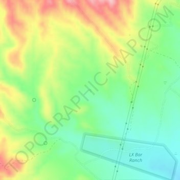
Name: Topografische Karte Ruin Point Tank, Höhe, Relief.

Ort: Ruin Point Tank, Yavapai County, Arizona, United States (34.16893 -111.82500 34.16953 -111.82440)

Durchschnittliche Höhe: 939 m

Minimale Höhe: 877 m

Maximale Höhe: 1.027 m

Andere topografische Karten

Klicken Sie auf eine Karte, um ihre Topografie, ihre Höhe und ihr Relief anzuzeigen.

Black Canyon City

United States > Arizona > Yavapai County

Black Canyon City is located at 34°4′11″N 112°8′22″W / 34.06972°N 112.13944°W / 34.06972; -112.13944 (34.069719, -112.139466), at an elevation of 1,975 feet (602 m).

Durchschnittliche Höhe: 700 m

Seligman

United States > Arizona > Yavapai County > Seligman

Seligman is located at 35°19′42″N 112°52′27″W / 35.32833°N 112.87417°W / 35.32833; -112.87417 (35.328199, −112.874303), at 5,240 feet (1,600 m) in elevation, alongside the Big Chino Wash, in a northern section of Chino Valley. The wash is a major tributary of the Verde River. Seligman is…

Durchschnittliche Höhe: 1.617 m

Mayer

United States > Arizona > Yavapai County

Durchschnittliche Höhe: 1.427 m

Paradise Acres

United States > Arizona > Yavapai County > Camp Verde

Durchschnittliche Höhe: 948 m

Tapco

United States > Arizona > Yavapai County

Durchschnittliche Höhe: 1.083 m

Walker

United States > Arizona > Yavapai County

Durchschnittliche Höhe: 2.039 m

Cleator

United States > Arizona > Yavapai County

Durchschnittliche Höhe: 1.083 m

Woodchute Mountain

United States > Arizona > Yavapai County

Durchschnittliche Höhe: 2.167 m

Granite Mountain

United States > Arizona > Yavapai County

Durchschnittliche Höhe: 1.915 m

Granite Mountain Wilderness

United States > Arizona > Yavapai County

Durchschnittliche Höhe: 1.718 m

Clear Creek

United States > Arizona > Yavapai County > Camp Verde

Durchschnittliche Höhe: 954 m

Cedar Bench Wilderness

United States > Arizona > Yavapai County

Cedar Bench Wilderness is a protected wilderness area in the Prescott National Forest in the U.S. state of Arizona. Established in 1984 under the Arizona Wilderness Act, the area protects the large "bench" that divides the Agua Fria and Verde River drainages. Elevations range from 4,500 feet (1,371 m) to 6,700…

Durchschnittliche Höhe: 1.349 m

Ocotillo

United States > Arizona > Yavapai County

Durchschnittliche Höhe: 1.302 m

Mesa Verde Estates

United States > Arizona > Yavapai County > Camp Verde

Durchschnittliche Höhe: 969 m

Clarkdale

United States > Arizona > Yavapai County

Durchschnittliche Höhe: 1.211 m

Arcosanti

United States > Arizona > Yavapai County

Arcosanti is a projected experimental town with a bronze bell casting business in Yavapai County, central Arizona, United States, 70 mi (110 km) north of Phoenix, at an elevation of 3,732 feet (1,138 m). Its arcology concept was proposed by Italian-American architect Paolo Soleri (1919–2013). He began…

Durchschnittliche Höhe: 1.130 m

Kirkland

United States > Arizona > Yavapai County

Durchschnittliche Höhe: 1.228 m

Chimney Rock

United States > Arizona > Yavapai County

Durchschnittliche Höhe: 1.441 m

Verde Village

United States > Arizona > Yavapai County

Durchschnittliche Höhe: 1.040 m

Glen Oaks

United States > Arizona > Yavapai County

Durchschnittliche Höhe: 1.717 m

Ash Fork

United States > Arizona > Yavapai County

Durchschnittliche Höhe: 1.576 m

Willow Spring

United States > Arizona > Yavapai County

Durchschnittliche Höhe: 1.447 m

Miller Valley

United States > Arizona > Yavapai County > Prescott

Durchschnittliche Höhe: 1.663 m

Briggs

United States > Arizona > Yavapai County

Durchschnittliche Höhe: 940 m

Yava

United States > Arizona > Yavapai County

Durchschnittliche Höhe: 1.095 m

Rüste dich für dein nächstes Abenteuer:

🧥Daunenjacken - Maximale Wärme bei geringem Gewicht
🧺Isolierte Picknickdecke - Perfekt für die Pause nach einer langen Wanderung
🎒Trekkingrucksäcke - Großvolumige Rucksäcke für Hütten- und Fernwanderungen
🧥Fleecejacken - Wärmende Zwischenschicht
🧣Multifunktionstuch - Schutz für Hals, Kopf oder Gesicht gegen Wind und Sonne

Als Amazon-Partner verdient diese Website an qualifizierten Käufen, ohne zusätzliche Kosten für Sie.