
Topografische Karte Lilburn
Interaktive Karte
Klicken Sie auf die Karte, um die Höhe anzuzeigen.
Über diese Karte
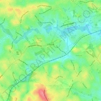
Name: Topografische Karte Lilburn, Höhe, Relief.
Ort: Lilburn, Gwinnett County, Georgia, United States (33.86505 -84.16771 33.90904 -84.10881)
Durchschnittliche Höhe: 291 m
Minimale Höhe: 259 m
Maximale Höhe: 342 m
Andere topografische Karten
Klicken Sie auf eine Karte, um ihre Topografie, ihre Höhe und ihr Relief anzuzeigen.
Buford
United States > Georgia > Gwinnett County
Buford, Gwinnett County, Georgia, United States
Durchschnittliche Höhe: 340 m
Norcross
United States > Georgia > Gwinnett County
Norcross, Gwinnett County, Georgia, 30071, United States
Durchschnittliche Höhe: 309 m
Northwest Harbor
United States > Georgia > Gwinnett County > Buford
Northwest Harbor, Buford, Gwinnett County, Georgia, 30158, United States
Durchschnittliche Höhe: 340 m
Suwanee
United States > Georgia > Gwinnett County
Suwanee, Gwinnett County, Georgia, United States
Durchschnittliche Höhe: 311 m
Sugar Hill
United States > Georgia > Gwinnett County
Sugar Hill, Gwinnett County, Georgia, United States
Durchschnittliche Höhe: 332 m
Duluth
United States > Georgia > Gwinnett County
Duluth, Gwinnett County, Georgia, United States
Durchschnittliche Höhe: 305 m
Sweet Water Park
United States > Georgia > Gwinnett County
Sweet Water Park, Regency Woods, Sweet Water, Gwinnett County, Georgia, United States
Durchschnittliche Höhe: 292 m
Snellville
United States > Georgia > Gwinnett County > Snellville
Snellville, Gwinnett County, Georgia, United States
Durchschnittliche Höhe: 300 m
Lawrenceville
United States > Georgia > Gwinnett County
Lawrenceville, Gwinnett County, Georgia, United States
Durchschnittliche Höhe: 312 m