
Topografische Karte Sugar Hill
Interaktive Karte
Klicken Sie auf die Karte, um die Höhe anzuzeigen.
Über diese Karte
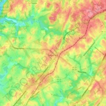
Name: Topografische Karte Sugar Hill, Höhe, Relief.
Ort: Sugar Hill, Gwinnett County, Georgia, United States (34.06466 -84.10169 34.15187 -84.01418)
Durchschnittliche Höhe: 332 m
Minimale Höhe: 277 m
Maximale Höhe: 383 m
According to the United States Census Bureau, as of 2010 the city of Sugar Hill had a total land area of 10.6 square miles (27.5 km2), of which 0.04 square miles (0.1 km2), or 0.33%, was water. The U.S. Geological Survey lists the city's elevation as 1,149 feet (350 m).
Andere topografische Karten
Klicken Sie auf eine Karte, um ihre Topografie, ihre Höhe und ihr Relief anzuzeigen.
Buford
United States > Georgia > Gwinnett County
Buford, Gwinnett County, Georgia, United States
Durchschnittliche Höhe: 340 m
Lilburn
United States > Georgia > Gwinnett County
Lilburn, Gwinnett County, Georgia, United States
Durchschnittliche Höhe: 291 m
Norcross
United States > Georgia > Gwinnett County
Norcross, Gwinnett County, Georgia, 30071, United States
Durchschnittliche Höhe: 309 m
Northwest Harbor
United States > Georgia > Gwinnett County > Buford
Northwest Harbor, Buford, Gwinnett County, Georgia, 30158, United States
Durchschnittliche Höhe: 340 m
Suwanee
United States > Georgia > Gwinnett County
Suwanee, Gwinnett County, Georgia, United States
Durchschnittliche Höhe: 311 m
Duluth
United States > Georgia > Gwinnett County
Duluth, Gwinnett County, Georgia, United States
Durchschnittliche Höhe: 305 m
Sweet Water Park
United States > Georgia > Gwinnett County
Sweet Water Park, Regency Woods, Sweet Water, Gwinnett County, Georgia, United States
Durchschnittliche Höhe: 292 m
Snellville
United States > Georgia > Gwinnett County > Snellville
Snellville, Gwinnett County, Georgia, United States
Durchschnittliche Höhe: 300 m
Lawrenceville
United States > Georgia > Gwinnett County
Lawrenceville, Gwinnett County, Georgia, United States
Durchschnittliche Höhe: 312 m