
Topografische Karte Sawmill
Interaktive Karte
Klicken Sie auf die Karte, um die Höhe anzuzeigen.
Über diese Karte
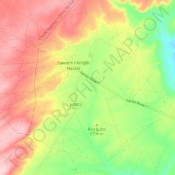
Name: Topografische Karte Sawmill, Höhe, Relief.
Ort: Sawmill, Apache County, Arizona, United States of America (35.87531 -109.18972 35.91007 -109.11189)
Durchschnittliche Höhe: 2.354 m
Minimale Höhe: 2.238 m
Maximale Höhe: 2.462 m
Andere topografische Karten
Klicken Sie auf eine Karte, um ihre Topografie, ihre Höhe und ihr Relief anzuzeigen.
Prescott
United States of America > Arizona > Prescott
Prescott, Yavapai County, Arizona, United States of America
Durchschnittliche Höhe: 1.674 m
Prescott Valley
United States of America > Arizona > Prescott Valley
Prescott Valley, Yavapai County, Arizona, United States of America
Durchschnittliche Höhe: 1.550 m
Cottonwood
United States of America > Arizona > Cottonwood
Cottonwood, Yavapai County, Arizona, 86326, United States of America
Durchschnittliche Höhe: 1.117 m
Horseshoe Bend
United States of America > Arizona > Page
Horseshoe Bend, Page, Coconino County, Arizona, 86040, United States of America
Durchschnittliche Höhe: 1.204 m
Picacho Peak
United States of America > Arizona
Picacho Peak, Pinal County, Arizona, 85141, United States of America
Durchschnittliche Höhe: 628 m
Big Springs
United States of America > Arizona
Big Springs, Coconino County, Arizona, United States of America
Durchschnittliche Höhe: 2.278 m
Dewey
United States of America > Arizona > Prescott Valley > Dewey
Dewey, Prescott Valley, Yavapai County, Arizona, 86329, United States of America
Durchschnittliche Höhe: 1.415 m
Scenic
United States of America > Arizona > Scenic
Scenic, Mohave County, Arizona, 86423, United States of America
Durchschnittliche Höhe: 575 m
South Mountain
United States of America > Arizona
South Mountain, Apache County, Arizona, 85920, United States of America
Durchschnittliche Höhe: 2.716 m
Young
United States of America > Arizona > Young
Young, Gila County, Arizona, United States of America
Durchschnittliche Höhe: 1.666 m
Webb
United States of America > Arizona > Webb
Webb, Maricopa County, Arizona, 85309, United States of America
Durchschnittliche Höhe: 334 m
Cedar Mill
United States of America > Arizona > Cedar Mill
Cedar Mill, Yavapai County, Arizona, United States of America
Durchschnittliche Höhe: 1.415 m
Thompson Butte
United States of America > Arizona
Thompson Butte, Yavapai County, Arizona, United States of America
Durchschnittliche Höhe: 1.492 m
Bonnie Blink
United States of America > Arizona > Sierra Vista > Bonnie Blink
Bonnie Blink, Sierra Vista, Cochise County, Arizona, United States of America
Durchschnittliche Höhe: 1.615 m
Eagletail Mountains Wilderness
United States of America > Arizona
Eagletail Mountains Wilderness, La Paz County, Arizona, United States of America
Durchschnittliche Höhe: 454 m
Hells Canyon
United States of America > Arizona
Hells Canyon, Mohave County, Arizona, United States of America
Durchschnittliche Höhe: 1.293 m