
Topografische Karte Sant'Anna
Interaktive Karte
Klicken Sie auf die Karte, um die Höhe anzuzeigen.
Über diese Karte
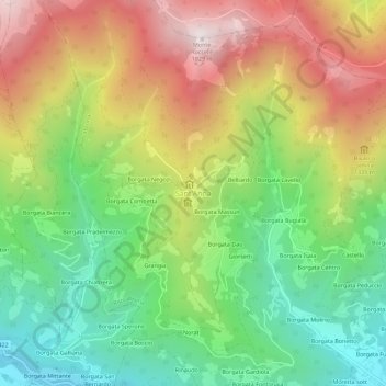
Name: Topografische Karte Sant'Anna, Höhe, Relief.
Ort: Sant'Anna, Roccabruna, Coni, Piémont, 12025, Italie (44.47785 7.28910 44.51785 7.32910)
Durchschnittliche Höhe: 1.164 m
Minimale Höhe: 664 m
Maximale Höhe: 1.815 m
Andere topografische Karten
Klicken Sie auf eine Karte, um ihre Topografie, ihre Höhe und ihr Relief anzuzeigen.
Monterosso Grana
Monterosso Grana, Coni, Piémont, Italie
Durchschnittliche Höhe: 1.128 m
Valloriate
Valloriate, Coni, Piémont, 12010, Italie
Durchschnittliche Höhe: 990 m
La Chenal
Italie > Piémont > Coni > Pontechianale
La Chenal, Pontechianale, Coni, Piémont, Italie
Durchschnittliche Höhe: 2.223 m
Chiotti
Italie > Piémont > Coni > Castelmagno
Chiotti, Castelmagno, Coni, Piémont, Italie
Durchschnittliche Höhe: 1.817 m
Grange Agnelli
Italie > Piémont > Coni > Acceglio
Grange Agnelli, Acceglio, Coni, Piémont, Italie
Durchschnittliche Höhe: 2.032 m
Puy
Italie > Piémont > Coni > Châteaudauphin
Puy, Châteaudauphin, Coni, Piémont, Italie
Durchschnittliche Höhe: 1.718 m
Ponte Maira
Italie > Piémont > Coni > Acceglio
Ponte Maira, Acceglio, Coni, Piémont, 12021, Italie
Durchschnittliche Höhe: 1.813 m
Bagnolo Piemonte
Bagnolo Piemonte, Coni, Piémont, 12031, Italie
Durchschnittliche Höhe: 573 m
Cime de Colle Longue
Italie > Piémont > Coni > Vinadio
Cime de Colle Longue, Vinadio, Coni, Piémont, Italie
Durchschnittliche Höhe: 2.461 m
San Vittore
Italie > Piémont > Coni > Fossano
San Vittore, Fossano, Coni, Piémont, 12044, Italie
Durchschnittliche Höhe: 391 m
Case Barberis
Italie > Piémont > Coni > Prà di Roburent
Case Barberis, Prà di Roburent, Roburent, Coni, Piémont, Italie
Durchschnittliche Höhe: 1.134 m
Limone Piemonte
Limone Piemonte, Coni, Piémont, 12015, Italie
Durchschnittliche Höhe: 1.619 m
Tetto Cace
Italie > Piémont > Coni > Vernante
Tetto Cace, Vernante, Coni, Piémont, 12019, Italie
Durchschnittliche Höhe: 1.192 m
Gias Lagarot
Italie > Piémont > Coni > Valdieri
Gias Lagarot, Valdieri, Coni, Piémont, Italie
Durchschnittliche Höhe: 2.051 m
Borgata Re
Italie > Piémont > Coni > Melle
Borgata Re, Melle, Coni, Piémont, Italie
Durchschnittliche Höhe: 920 m
Campagnole
Italie > Piémont > Coni > Revello
Campagnole, Revello, Coni, Piémont, 12036, Italie
Durchschnittliche Höhe: 340 m
Gias di Stau
Italie > Piémont > Coni > Pietraporzio
Gias di Stau, Pietraporzio, Coni, Piémont, Italie
Durchschnittliche Höhe: 2.222 m
Lago Inferiore di Roburent
Italie > Piémont > Coni > Argentera
Lago Inferiore di Roburent, Argentera, Coni, Piémont, Italie
Durchschnittliche Höhe: 2.375 m
Mont Viso
Italie > Piémont > Coni > Pontechianale
Mont Viso, Pontechianale, Coni, Piémont, Italie
Durchschnittliche Höhe: 2.985 m
Tetto Garaud
Italie > Piémont > Coni > Vernante
Tetto Garaud, Vernante, Coni, Piémont, 12019, Italie
Durchschnittliche Höhe: 1.127 m
Frazione Puà
Italie > Piémont > Coni > Pratolungo
Frazione Puà, Pratolungo, Vinadio, Coni, Piémont, Italie
Durchschnittliche Höhe: 1.304 m