
Topografische Karte Sampeyre
Interaktive Karte
Klicken Sie auf die Karte, um die Höhe anzuzeigen.
Über diese Karte
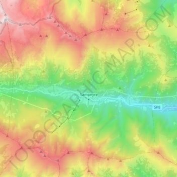
Name: Topografische Karte Sampeyre, Höhe, Relief.
Ort: Sampeyre, Coni, Piémont, Italie (44.53679 7.11423 44.62988 7.27442)
Durchschnittliche Höhe: 1.719 m
Minimale Höhe: 752 m
Maximale Höhe: 2.981 m
Sampeyre (en français Saint-Pierre) est une commune de la province de Coni dans le Piémont en Italie, située à 976 mètres d'altitude. Ses habitants sont appelés les sampeyresi.
Andere topografische Karten
Klicken Sie auf eine Karte, um ihre Topografie, ihre Höhe und ihr Relief anzuzeigen.
Monterosso Grana
Monterosso Grana, Coni, Piémont, Italie
Durchschnittliche Höhe: 1.128 m
Valloriate
Valloriate, Coni, Piémont, 12010, Italie
Durchschnittliche Höhe: 990 m
La Chenal
Italie > Piémont > Coni > Pontechianale
La Chenal, Pontechianale, Coni, Piémont, Italie
Durchschnittliche Höhe: 2.223 m
Chiotti
Italie > Piémont > Coni > Castelmagno
Chiotti, Castelmagno, Coni, Piémont, Italie
Durchschnittliche Höhe: 1.817 m
Grange Agnelli
Italie > Piémont > Coni > Acceglio
Grange Agnelli, Acceglio, Coni, Piémont, Italie
Durchschnittliche Höhe: 2.032 m
Puy
Italie > Piémont > Coni > Châteaudauphin
Puy, Châteaudauphin, Coni, Piémont, Italie
Durchschnittliche Höhe: 1.718 m
Ponte Maira
Italie > Piémont > Coni > Acceglio
Ponte Maira, Acceglio, Coni, Piémont, 12021, Italie
Durchschnittliche Höhe: 1.813 m
Bagnolo Piemonte
Bagnolo Piemonte, Coni, Piémont, 12031, Italie
Durchschnittliche Höhe: 573 m
Cime de Colle Longue
Italie > Piémont > Coni > Vinadio
Cime de Colle Longue, Vinadio, Coni, Piémont, Italie
Durchschnittliche Höhe: 2.461 m
San Vittore
Italie > Piémont > Coni > Fossano
San Vittore, Fossano, Coni, Piémont, 12044, Italie
Durchschnittliche Höhe: 391 m
Case Barberis
Italie > Piémont > Coni > Prà di Roburent
Case Barberis, Prà di Roburent, Roburent, Coni, Piémont, Italie
Durchschnittliche Höhe: 1.134 m
Limone Piemonte
Limone Piemonte, Coni, Piémont, 12015, Italie
Durchschnittliche Höhe: 1.619 m
Tetto Cace
Italie > Piémont > Coni > Vernante
Tetto Cace, Vernante, Coni, Piémont, 12019, Italie
Durchschnittliche Höhe: 1.192 m
Gias Lagarot
Italie > Piémont > Coni > Valdieri
Gias Lagarot, Valdieri, Coni, Piémont, Italie
Durchschnittliche Höhe: 2.051 m
Borgata Re
Italie > Piémont > Coni > Melle
Borgata Re, Melle, Coni, Piémont, Italie
Durchschnittliche Höhe: 920 m
Campagnole
Italie > Piémont > Coni > Revello
Campagnole, Revello, Coni, Piémont, 12036, Italie
Durchschnittliche Höhe: 340 m
Gias di Stau
Italie > Piémont > Coni > Pietraporzio
Gias di Stau, Pietraporzio, Coni, Piémont, Italie
Durchschnittliche Höhe: 2.222 m
Lago Inferiore di Roburent
Italie > Piémont > Coni > Argentera
Lago Inferiore di Roburent, Argentera, Coni, Piémont, Italie
Durchschnittliche Höhe: 2.375 m
Mont Viso
Italie > Piémont > Coni > Pontechianale
Mont Viso, Pontechianale, Coni, Piémont, Italie
Durchschnittliche Höhe: 2.985 m
Tetto Garaud
Italie > Piémont > Coni > Vernante
Tetto Garaud, Vernante, Coni, Piémont, 12019, Italie
Durchschnittliche Höhe: 1.127 m
Frazione Puà
Italie > Piémont > Coni > Pratolungo
Frazione Puà, Pratolungo, Vinadio, Coni, Piémont, Italie
Durchschnittliche Höhe: 1.304 m