
Topografische Karte Matroos
Interaktive Karte
Klicken Sie auf die Karte, um die Höhe anzuzeigen.
Über diese Karte
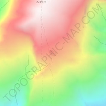
Name: Topografische Karte Matroos, Höhe, Relief.
Durchschnittliche Höhe: 1.642 m
Minimale Höhe: 920 m
Maximale Höhe: 2.237 m
Andere topografische Karten
Klicken Sie auf eine Karte, um ihre Topografie, ihre Höhe und ihr Relief anzuzeigen.
Worcester
South Africa > Western Cape > Cape Winelands District Municipality > Breede Valley Local Municipality
Worcester, Breede Valley Local Municipality, Cape Winelands District Municipality, Western Cape, 6849, South Africa
Durchschnittliche Höhe: 252 m
Touws River
South Africa > Western Cape > Cape Winelands District Municipality > Breede Valley Local Municipality
Touws River, Breede Valley Local Municipality, Cape Winelands District Municipality, Western Cape, South Africa
Durchschnittliche Höhe: 822 m
De Doorns
South Africa > Western Cape > Cape Winelands District Municipality > Breede Valley Local Municipality
De Doorns, Breede Valley Local Municipality, Cape Winelands District Municipality, Western Cape, South Africa
Durchschnittliche Höhe: 683 m
Rawsonville
South Africa > Western Cape > Cape Winelands District Municipality > Breede Valley Local Municipality > Rawsonville
Rawsonville, Breede Valley Local Municipality, Cape Winelands District Municipality, Western Cape, South Africa
Durchschnittliche Höhe: 231 m