
Topografische Karte Touws River
Interaktive Karte
Klicken Sie auf die Karte, um die Höhe anzuzeigen.
Über diese Karte
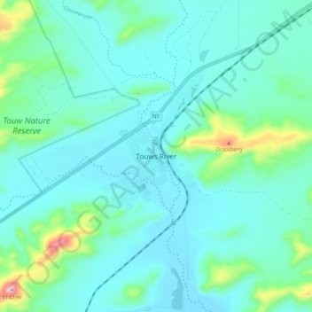
Name: Topografische Karte Touws River, Höhe, Relief.
Durchschnittliche Höhe: 822 m
Minimale Höhe: 760 m
Maximale Höhe: 1.144 m
Touws River is located at an elevation of 770 metres (2,530 ft) on the southwestern edge of the Great Karoo, east of the Hex River Mountains and north of the Langeberg, at the point where the Donkeys River flows into the Touws River. It lies just to the south of the N1 highway, 180 kilometres (110 mi) by road from Cape Town. The railway line passes through the town, with the yards and depot being located just to the north-east; by rail it is 257 kilometres (160 mi) from Cape Town.
Andere topografische Karten
Klicken Sie auf eine Karte, um ihre Topografie, ihre Höhe und ihr Relief anzuzeigen.
Worcester
South Africa > Western Cape > Cape Winelands District Municipality > Breede Valley Local Municipality
Worcester, Breede Valley Local Municipality, Cape Winelands District Municipality, Western Cape, 6849, South Africa
Durchschnittliche Höhe: 252 m
De Doorns
South Africa > Western Cape > Cape Winelands District Municipality > Breede Valley Local Municipality
De Doorns, Breede Valley Local Municipality, Cape Winelands District Municipality, Western Cape, South Africa
Durchschnittliche Höhe: 683 m
Matroos
South Africa > Western Cape > Cape Winelands District Municipality > Breede Valley Local Municipality
Matroos, Breede Valley Ward 3, Breede Valley Local Municipality, Cape Winelands District Municipality, Western Cape, South Africa
Durchschnittliche Höhe: 1.642 m
Rawsonville
South Africa > Western Cape > Cape Winelands District Municipality > Breede Valley Local Municipality > Rawsonville
Rawsonville, Breede Valley Local Municipality, Cape Winelands District Municipality, Western Cape, South Africa
Durchschnittliche Höhe: 231 m