
Topografische Karte Thornbury
Interaktive Karte
Klicken Sie auf die Karte, um die Höhe anzuzeigen.
Über diese Karte
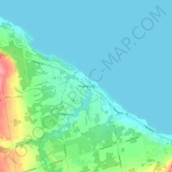
Name: Topografische Karte Thornbury, Höhe, Relief.
Durchschnittliche Höhe: 202 m
Minimale Höhe: 174 m
Maximale Höhe: 335 m
Andere topografische Karten
Klicken Sie auf eine Karte, um ihre Topografie, ihre Höhe und ihr Relief anzuzeigen.
Grey Highlands
Canada > Ontario > Grey County
Grey Highlands, Grey County, Southwestern Ontario, Ontario, Canada
Durchschnittliche Höhe: 428 m
Georgian Bluffs
Canada > Ontario > Grey County
Georgian Bluffs, Grey County, Southwestern Ontario, Ontario, Canada
Durchschnittliche Höhe: 228 m
West Grey
Canada > Ontario > Grey County
West Grey, Grey County, Southwestern Ontario, Ontario, Canada
Durchschnittliche Höhe: 357 m
Owen Sound
Canada > Ontario > Grey County
Owen Sound, Grey County, Southwestern Ontario, Ontario, Canada
Durchschnittliche Höhe: 222 m
Meaford
Canada > Ontario > Grey County
Meaford, Grey County, Southwestern Ontario, Ontario, Canada
Durchschnittliche Höhe: 222 m
Bognor
Canada > Ontario > Grey County > Meaford
Bognor, Meaford, Grey County, Southwestern Ontario, Ontario, Canada
Durchschnittliche Höhe: 266 m
Kemble
Canada > Ontario > Grey County > Georgian Bluffs
Kemble, Georgian Bluffs, Grey County, Ontario, Canada
Durchschnittliche Höhe: 243 m