
Topografische Karte Meaford
Interaktive Karte
Klicken Sie auf die Karte, um die Höhe anzuzeigen.
Über diese Karte
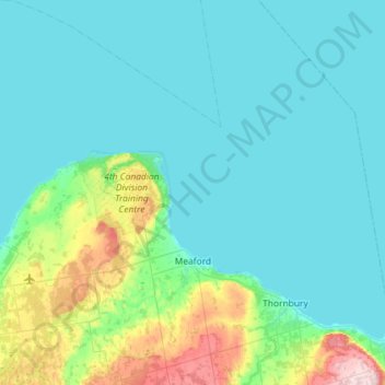
Name: Topografische Karte Meaford, Höhe, Relief.
Ort: Meaford, Grey County, Southwestern Ontario, Ontario, Canada (44.47455 -80.92573 44.88494 -80.50210)
Durchschnittliche Höhe: 222 m
Minimale Höhe: 173 m
Maximale Höhe: 520 m
Andere topografische Karten
Klicken Sie auf eine Karte, um ihre Topografie, ihre Höhe und ihr Relief anzuzeigen.
Thornbury
Canada > Ontario > Grey County
Thornbury, The Blue Mountains, Grey County, Ontario, N0H 2P0, Canada
Durchschnittliche Höhe: 202 m
Grey Highlands
Canada > Ontario > Grey County
Grey Highlands, Grey County, Southwestern Ontario, Ontario, Canada
Durchschnittliche Höhe: 428 m
Georgian Bluffs
Canada > Ontario > Grey County
Georgian Bluffs, Grey County, Southwestern Ontario, Ontario, Canada
Durchschnittliche Höhe: 228 m
West Grey
Canada > Ontario > Grey County
West Grey, Grey County, Southwestern Ontario, Ontario, Canada
Durchschnittliche Höhe: 357 m
Owen Sound
Canada > Ontario > Grey County
Owen Sound, Grey County, Southwestern Ontario, Ontario, Canada
Durchschnittliche Höhe: 222 m
Bognor
Canada > Ontario > Grey County > Meaford
Bognor, Meaford, Grey County, Southwestern Ontario, Ontario, Canada
Durchschnittliche Höhe: 266 m
Kemble
Canada > Ontario > Grey County > Georgian Bluffs
Kemble, Georgian Bluffs, Grey County, Ontario, Canada
Durchschnittliche Höhe: 243 m