
Topografische Karte Port Ludlow
Interaktive Karte
Klicken Sie auf die Karte, um die Höhe anzuzeigen.
Über diese Karte
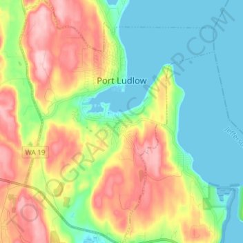
Name: Topografische Karte Port Ludlow, Höhe, Relief.
Durchschnittliche Höhe: 64 m
Minimale Höhe: -1 m
Maximale Höhe: 169 m
Andere topografische Karten
Klicken Sie auf eine Karte, um ihre Topografie, ihre Höhe und ihr Relief anzuzeigen.
Hoh River
United States > Washington > Jefferson County
Hoh River, Jefferson County, Washington, United States
Durchschnittliche Höhe: 531 m
Port Townsend
United States > Washington > Jefferson County
Port Townsend, Jefferson County, Washington, United States
Durchschnittliche Höhe: 19 m
Port Townsend
United States > Washington > Jefferson County > Port Townsend > Port Townsend
Port Townsend, Jefferson County, Washington, 98386, United States
Durchschnittliche Höhe: 18 m
Tukey
United States > Washington > Jefferson County
Tukey, Jefferson County, Washington, United States
Durchschnittliche Höhe: 34 m
Mount Townsend
United States > Washington > Jefferson County
Mount Townsend, Jefferson County, Washington, United States
Durchschnittliche Höhe: 1.518 m
Mount Olympus
United States > Washington > Jefferson County
Mount Olympus, Jefferson County, Washington, United States
Durchschnittliche Höhe: 1.934 m
Brinnon
United States > Washington > Jefferson County
Brinnon, Jefferson County, Washington, 98320, United States
Durchschnittliche Höhe: 204 m
Quilcene
United States > Washington > Jefferson County
Quilcene, Jefferson County, Washington, United States
Durchschnittliche Höhe: 116 m
Swansonville
United States > Washington > Jefferson County > Port Ludlow
Swansonville, Port Ludlow, Jefferson County, Washington, 98365, United States
Durchschnittliche Höhe: 79 m