
Topografische Karte Hoh River
Interaktive Karte
Klicken Sie auf die Karte, um die Höhe anzuzeigen.
Über diese Karte
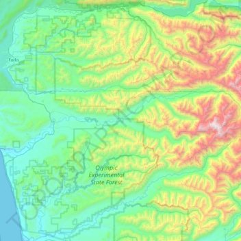
Name: Topografische Karte Hoh River, Höhe, Relief.
Ort: Hoh River, Jefferson County, Washington, United States (47.74101 -124.43399 47.88389 -123.62099)
Durchschnittliche Höhe: 531 m
Minimale Höhe: -1 m
Maximale Höhe: 2.353 m
The Hoh River Trail, managed by the National Park Service, begins at the national park's Hoh Rain Forest Visitor Center at the end of the Upper Hoh Road. The trail follows the Hoh River east into the heart of the park. After 17.5 mi (28.2 km) it reaches Glacier Meadows near Mount Olympus's Blue Glacier. The Hoh River Trail begins at an altitude of about 600 ft (180 m) and the trail is mostly flat for about 13 mi (21 km), after which it ascends steeply to Glacier Meadows, altitude 4,300 ft (1,300 m). The trail passes through the Hoh Rain Forest, a temperate rain forest, and, closer to Mount Olympus, montane forests and subalpine meadows. There are a number of backcountry campsites along the trail. Mountaineers wishing to climb Mount Olympus typically use the Hoh River Trail to reach the mountain. The climb requires experience with glacier travel and crevasse rescue skills.
Andere topografische Karten
Klicken Sie auf eine Karte, um ihre Topografie, ihre Höhe und ihr Relief anzuzeigen.
Port Ludlow
United States > Washington > Jefferson County
Port Ludlow, Jefferson County, Washington, 98365, United States
Durchschnittliche Höhe: 64 m
Port Townsend
United States > Washington > Jefferson County > Port Townsend > Port Townsend
Port Townsend, Jefferson County, Washington, 98386, United States
Durchschnittliche Höhe: 18 m
Port Townsend
United States > Washington > Jefferson County
Port Townsend, Jefferson County, Washington, United States
Durchschnittliche Höhe: 19 m
Tukey
United States > Washington > Jefferson County
Tukey, Jefferson County, Washington, United States
Durchschnittliche Höhe: 34 m
Mount Townsend
United States > Washington > Jefferson County
Mount Townsend, Jefferson County, Washington, United States
Durchschnittliche Höhe: 1.518 m
Mount Olympus
United States > Washington > Jefferson County
Mount Olympus, Jefferson County, Washington, United States
Durchschnittliche Höhe: 1.934 m
Brinnon
United States > Washington > Jefferson County
Brinnon, Jefferson County, Washington, 98320, United States
Durchschnittliche Höhe: 204 m
Quilcene
United States > Washington > Jefferson County
Quilcene, Jefferson County, Washington, United States
Durchschnittliche Höhe: 116 m
Swansonville
United States > Washington > Jefferson County > Port Ludlow
Swansonville, Port Ludlow, Jefferson County, Washington, 98365, United States
Durchschnittliche Höhe: 79 m