
Topografische Karte Vinhais
Interaktive Karte
Klicken Sie auf die Karte, um die Höhe anzuzeigen.
Über diese Karte
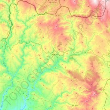
Name: Topografische Karte Vinhais, Höhe, Relief.
Ort: Vinhais, Bragança, Portugal (41.67113 -7.21360 41.99076 -6.86096)
Durchschnittliche Höhe: 779 m
Minimale Höhe: 258 m
Maximale Höhe: 1.527 m
It is perched on the slopes of the Coroa mountains at an altitude of approximately 600 meters, protected from the cold winds of the north by the Ciradelha mountain, where in remote times there was a Luso-Roman castro. On the south side is the Tuela River valley. There are three other rivers in the concelho: the Rabaçal, the Mente, and the Baceiro. They are relatively unpolluted and provide fish for locals and tourists. The Baceiro has a trout hatchery which is deactivated but will be reopened soon.
Andere topografische Karten
Klicken Sie auf eine Karte, um ihre Topografie, ihre Höhe und ihr Relief anzuzeigen.
Penhas Juntas
Penhas Juntas, Vinhais, Bragança, Portugal
Durchschnittliche Höhe: 715 m
Montesinho Nature Park
Portugal > Bragança > Bragança > Espinhosela
Montesinho Nature Park, Espinhosela, Bragança, 5300-245, Portugal
Durchschnittliche Höhe: 881 m
Carrazeda de Ansiães
Carrazeda de Ansiães, Bragança, Portugal
Durchschnittliche Höhe: 538 m
Macedo de Cavaleiros
Portugal > Bragança > Macedo de Cavaleiros
Macedo de Cavaleiros, Bragança, Portugal
Durchschnittliche Höhe: 594 m
Mua
Portugal > Bragança > Torre de Moncorvo
Mua, Torre de Moncorvo, Bragança, Portugal
Durchschnittliche Höhe: 695 m