
Topografische Karte Carrazeda de Ansiães
Interaktive Karte
Klicken Sie auf die Karte, um die Höhe anzuzeigen.
Über diese Karte
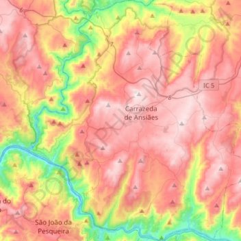
Name: Topografische Karte Carrazeda de Ansiães, Höhe, Relief.
Ort: Carrazeda de Ansiães, Bragança, Portugal (41.13549 -7.43189 41.33852 -7.18654)
Durchschnittliche Höhe: 538 m
Minimale Höhe: 75 m
Maximale Höhe: 886 m
Carrazeda de Ansiães has a warm-summer Mediterranean climate (Köppen: Csb) characterized by cool winters and warm to hot summers with cool nights due to its altitude.[4] As with other municipalities near the Douro Valley, altitude plays a role in temperature. Places closer to the valley at lower altitudes generally have higher temperatures (averaging around 16 °C (61 °F)), and hot to very hot summers (Köppen: Csa), while places higher in altitude (e.g. 800 m (2,600 ft)) tend to have lower average temperatures, generally around 11 °C (52 °F), with temperatures similar to those shown in the climate box below:
Andere topografische Karten
Klicken Sie auf eine Karte, um ihre Topografie, ihre Höhe und ihr Relief anzuzeigen.
Penhas Juntas
Penhas Juntas, Vinhais, Bragança, Portugal
Durchschnittliche Höhe: 715 m
Montesinho Nature Park
Portugal > Bragança > Bragança > Espinhosela
Montesinho Nature Park, Espinhosela, Bragança, 5300-245, Portugal
Durchschnittliche Höhe: 881 m
Macedo de Cavaleiros
Portugal > Bragança > Macedo de Cavaleiros
Macedo de Cavaleiros, Bragança, Portugal
Durchschnittliche Höhe: 594 m
Mua
Portugal > Bragança > Torre de Moncorvo
Mua, Torre de Moncorvo, Bragança, Portugal
Durchschnittliche Höhe: 695 m