
Topografische Karte Labastida/Bastida
Interaktive Karte
Klicken Sie auf die Karte, um die Höhe anzuzeigen.
Über diese Karte
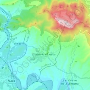
Name: Topografische Karte Labastida/Bastida, Höhe, Relief.
Durchschnittliche Höhe: 611 m
Minimale Höhe: 423 m
Maximale Höhe: 1.252 m
The town is at 529m altitude, and is positioned between the River Ebro and the Sierra de Toloño mountain range.
Andere topografische Karten
Klicken Sie auf eine Karte, um ihre Topografie, ihre Höhe und ihr Relief anzuzeigen.
Salinillas de Buradón/Gatzaga Buradon
Spain > Autonomous Community of the Basque Country > Arabako Errioxa/Rioja Alavesa > Labastida/Bastida
Salinillas de Buradón/Gatzaga Buradon, Labastida/Bastida, Arabako Errioxa/Rioja Alavesa, Álava, Autonomous Community of the Basque Country, Spain
Durchschnittliche Höhe: 599 m
Laguardia
Spain > Autonomous Community of the Basque Country > Arabako Errioxa/Rioja Alavesa
Laguardia, Arabako Errioxa/Rioja Alavesa, Álava, Autonomous Community of the Basque Country, Spain
Durchschnittliche Höhe: 592 m
Oyón/Oion
Spain > Autonomous Community of the Basque Country > Arabako Errioxa/Rioja Alavesa
Oyón/Oion, Arabako Errioxa/Rioja Alavesa, Álava, Autonomous Community of the Basque Country, 01320, Spain
Durchschnittliche Höhe: 572 m