
Topografische Karte Laguardia
Interaktive Karte
Klicken Sie auf die Karte, um die Höhe anzuzeigen.
Über diese Karte
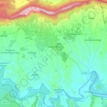
Name: Topografische Karte Laguardia, Höhe, Relief.
Durchschnittliche Höhe: 592 m
Minimale Höhe: 369 m
Maximale Höhe: 1.385 m
Andere topografische Karten
Klicken Sie auf eine Karte, um ihre Topografie, ihre Höhe und ihr Relief anzuzeigen.
Labastida/Bastida
Spain > Autonomous Community of the Basque Country > Arabako Errioxa/Rioja Alavesa
Labastida/Bastida, Arabako Errioxa/Rioja Alavesa, Álava, Autonomous Community of the Basque Country, 01330, Spain
Durchschnittliche Höhe: 611 m
Salinillas de Buradón/Gatzaga Buradon
Spain > Autonomous Community of the Basque Country > Arabako Errioxa/Rioja Alavesa > Labastida/Bastida
Salinillas de Buradón/Gatzaga Buradon, Labastida/Bastida, Arabako Errioxa/Rioja Alavesa, Álava, Autonomous Community of the Basque Country, Spain
Durchschnittliche Höhe: 599 m
Oyón/Oion
Spain > Autonomous Community of the Basque Country > Arabako Errioxa/Rioja Alavesa
Oyón/Oion, Arabako Errioxa/Rioja Alavesa, Álava, Autonomous Community of the Basque Country, 01320, Spain
Durchschnittliche Höhe: 572 m