
Topografische Karte Chino Valley
Interaktive Karte
Klicken Sie auf die Karte, um die Höhe anzuzeigen.
Über diese Karte
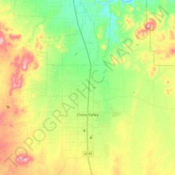
Name: Topografische Karte Chino Valley, Höhe, Relief.
Durchschnittliche Höhe: 1.454 m
Minimale Höhe: 1.288 m
Maximale Höhe: 1.700 m
The town is in north-central Arizona, on state Highway 89, 15 miles (24 km) north of Prescott and 35 miles (56 km) south of Ash Fork, which is on Interstate 40. Chino Valley is at an elevation of about 4,750 feet (1,450 m).
Andere topografische Karten
Klicken Sie auf eine Karte, um ihre Topografie, ihre Höhe und ihr Relief anzuzeigen.
Prescott
United States > Arizona > Yavapai County
Prescott, Yavapai County, Arizona, United States
Durchschnittliche Höhe: 1.674 m
Black Canyon City
United States > Arizona > Yavapai County
Black Canyon City, Yavapai County, Arizona, 85324, United States
Durchschnittliche Höhe: 763 m
Ash Fork
United States > Arizona > Yavapai County > Ash Fork
Ash Fork, Yavapai County, Arizona, 86320, United States
Durchschnittliche Höhe: 1.561 m
Cottonwood
United States > Arizona > Yavapai County
Cottonwood, Yavapai County, Arizona, United States
Durchschnittliche Höhe: 1.118 m
Prescott Valley
United States > Arizona > Yavapai County
Prescott Valley, Yavapai County, Arizona, United States
Durchschnittliche Höhe: 1.550 m
Sedona
United States > Arizona > Yavapai County
Sedona, Yavapai County, Arizona, 86336, United States
Durchschnittliche Höhe: 1.342 m