
Topografische Karte Prescott
Interaktive Karte
Klicken Sie auf die Karte, um die Höhe anzuzeigen.
Über diese Karte
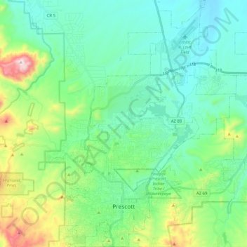
Name: Topografische Karte Prescott, Höhe, Relief.
Ort: Prescott, Yavapai County, Arizona, United States (34.51253 -112.52996 34.67994 -112.37610)
Durchschnittliche Höhe: 1.674 m
Minimale Höhe: 1.486 m
Maximale Höhe: 2.302 m
Prescott is in the Bradshaw Mountains of central Arizona, at an elevation of 5,400 feet (1,600 m). The city has a Mediterranean climate (Köppen Csa); however, unlike most other locations in this climate class, there is a pronounced summer wet season due to the North American Monsoon.
Andere topografische Karten
Klicken Sie auf eine Karte, um ihre Topografie, ihre Höhe und ihr Relief anzuzeigen.
Chino Valley
United States > Arizona > Yavapai County
Chino Valley, Yavapai County, Arizona, 86323, United States
Durchschnittliche Höhe: 1.454 m
Black Canyon City
United States > Arizona > Yavapai County
Black Canyon City, Yavapai County, Arizona, 85324, United States
Durchschnittliche Höhe: 763 m
Ash Fork
United States > Arizona > Yavapai County > Ash Fork
Ash Fork, Yavapai County, Arizona, 86320, United States
Durchschnittliche Höhe: 1.561 m
Cottonwood
United States > Arizona > Yavapai County
Cottonwood, Yavapai County, Arizona, United States
Durchschnittliche Höhe: 1.118 m
Prescott Valley
United States > Arizona > Yavapai County
Prescott Valley, Yavapai County, Arizona, United States
Durchschnittliche Höhe: 1.550 m
Sedona
United States > Arizona > Yavapai County
Sedona, Yavapai County, Arizona, 86336, United States
Durchschnittliche Höhe: 1.342 m