
Topografische Karte Lake Curry
Interaktive Karte
Klicken Sie auf die Karte, um die Höhe anzuzeigen.
Über diese Karte
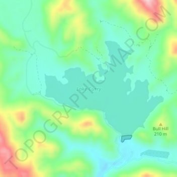
Name: Topografische Karte Lake Curry, Höhe, Relief.
Ort: Lake Curry, Napa County, California, United States (38.35750 -122.14085 38.37204 -122.11767)
Durchschnittliche Höhe: 153 m
Minimale Höhe: 89 m
Maximale Höhe: 304 m
Andere topografische Karten
Klicken Sie auf eine Karte, um ihre Topografie, ihre Höhe und ihr Relief anzuzeigen.
Oakville
United States > California > Napa County
Oakville, Napa County, California, 94562, United States
Durchschnittliche Höhe: 61 m
Lake Berryessa
United States > California > Napa County
Lake Berryessa, Napa County, California, United States
Durchschnittliche Höhe: 322 m
Calistoga
United States > California > Napa County
Calistoga, Napa County, California, 94515, United States
Durchschnittliche Höhe: 160 m
Bothe-Napa Valley State Park
United States > California > Napa County
Bothe-Napa Valley State Park, Napa County, California, United States
Durchschnittliche Höhe: 354 m
Napa
United States > California > Napa County
Napa, Napa County, California, United States
Durchschnittliche Höhe: 92 m