
Topografische Karte Oakville
Interaktive Karte
Klicken Sie auf die Karte, um die Höhe anzuzeigen.
Über diese Karte
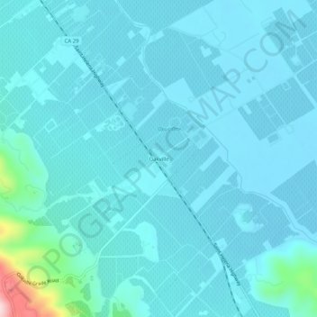
Name: Topografische Karte Oakville, Höhe, Relief.
Ort: Oakville, Napa County, California, 94562, United States (38.41685 -122.42220 38.45685 -122.38220)
Durchschnittliche Höhe: 61 m
Minimale Höhe: 32 m
Maximale Höhe: 333 m
Andere topografische Karten
Klicken Sie auf eine Karte, um ihre Topografie, ihre Höhe und ihr Relief anzuzeigen.
Lake Berryessa
United States > California > Napa County
Lake Berryessa, Napa County, California, United States
Durchschnittliche Höhe: 322 m
Calistoga
United States > California > Napa County
Calistoga, Napa County, California, 94515, United States
Durchschnittliche Höhe: 160 m
Lake Curry
United States > California > Napa County
Lake Curry, Napa County, California, United States
Durchschnittliche Höhe: 153 m
Bothe-Napa Valley State Park
United States > California > Napa County
Bothe-Napa Valley State Park, Napa County, California, United States
Durchschnittliche Höhe: 354 m
Napa
United States > California > Napa County
Napa, Napa County, California, United States
Durchschnittliche Höhe: 92 m