
Topografische Karte Great Sand Dunes National Park
Interaktive Karte
Klicken Sie auf die Karte, um die Höhe anzuzeigen.
Über diese Karte
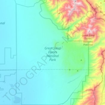
Name: Topografische Karte Great Sand Dunes National Park, Höhe, Relief.
Durchschnittliche Höhe: 2.616 m
Minimale Höhe: 2.292 m
Maximale Höhe: 4.100 m
In 1848, John C. Frémont was hired to find a railroad route from St. Louis to California. He crossed the Sangre de Cristos into the San Luis Valley in winter, courting disaster but proving that a winter crossing of this range was possible. He was followed in 1853 by Captain John Gunnison of the Corps of Topographical Engineers. Gunnison's party crossed the dunefield on horseback.[11]
Andere topografische Karten
Klicken Sie auf eine Karte, um ihre Topografie, ihre Höhe und ihr Relief anzuzeigen.
La Garita
United States > Colorado > Saguache County
La Garita, Saguache County, Colorado, United States
Durchschnittliche Höhe: 2.384 m
Twin Mountains
United States > Colorado > Saguache County
Twin Mountains, Saguache County, Colorado, United States
Durchschnittliche Höhe: 2.919 m
Challenger Point
United States > Colorado > Saguache County
Challenger Point, Saguache County, Colorado, United States
Durchschnittliche Höhe: 3.781 m
Crestone
United States > Colorado > Saguache County
Crestone, Saguache County, Colorado, United States
Durchschnittliche Höhe: 2.444 m
Great Sand Dunes National Preserve
United States > Colorado > Saguache County
Great Sand Dunes National Preserve, Saguache County, Colorado, United States
Durchschnittliche Höhe: 2.792 m