
Topografische Karte Crestone
Interaktive Karte
Klicken Sie auf die Karte, um die Höhe anzuzeigen.
Über diese Karte
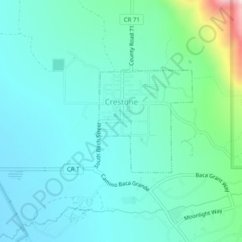
Name: Topografische Karte Crestone, Höhe, Relief.
Ort: Crestone, Saguache County, Colorado, United States (37.98753 -105.70240 37.99896 -105.68913)
Durchschnittliche Höhe: 2.444 m
Minimale Höhe: 2.357 m
Maximale Höhe: 2.842 m
Andere topografische Karten
Klicken Sie auf eine Karte, um ihre Topografie, ihre Höhe und ihr Relief anzuzeigen.
La Garita
United States > Colorado > Saguache County
La Garita, Saguache County, Colorado, United States
Durchschnittliche Höhe: 2.384 m
Twin Mountains
United States > Colorado > Saguache County
Twin Mountains, Saguache County, Colorado, United States
Durchschnittliche Höhe: 2.919 m
Challenger Point
United States > Colorado > Saguache County
Challenger Point, Saguache County, Colorado, United States
Durchschnittliche Höhe: 3.781 m
Great Sand Dunes National Park
United States > Colorado > Saguache County
Great Sand Dunes National Park, Saguache County, Colorado, United States
Durchschnittliche Höhe: 2.616 m
Great Sand Dunes National Preserve
United States > Colorado > Saguache County
Great Sand Dunes National Preserve, Saguache County, Colorado, United States
Durchschnittliche Höhe: 2.792 m