
Topografische Karte Alabama
Interaktive Karte
Klicken Sie auf die Karte, um die Höhe anzuzeigen.
Über diese Karte
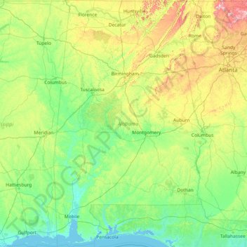
Name: Topografische Karte Alabama, Höhe, Relief.
Ort: Alabama, United States (30.14338 -88.47310 35.00811 -84.88829)
Durchschnittliche Höhe: 136 m
Minimale Höhe: -3 m
Maximale Höhe: 1.232 m
Alabama is bordered by the states of Tennessee to the north, Georgia to the east, Florida to the south, and Mississippi to the west. Alabama has coastline at the Gulf of Mexico, in the extreme southern edge of the state. The state ranges in elevation from sea level at Mobile Bay to more than 2,000 feet (610 m) in the northeast, to Mount Cheaha at 2,413 ft (735 m).
Andere topografische Karten
Klicken Sie auf eine Karte, um ihre Topografie, ihre Höhe und ihr Relief anzuzeigen.
Los Angeles
Los Angeles, California, United States
Durchschnittliche Höhe: 241 m
Manhattan
United States > New York > New York County > New York
Manhattan, New York County, New York, United States
Durchschnittliche Höhe: 16 m
Brooklyn
United States > New York > New York
Brooklyn, Kings County, New York, United States
Durchschnittliche Höhe: 9 m
Lapeer County
Lapeer County, Michigan, United States
Durchschnittliche Höhe: 261 m
Houston
United States > Texas > Harris County
Houston, Harris County, Texas, United States
Durchschnittliche Höhe: 25 m
Santa Cruz
United States > California > Santa Cruz County
Santa Cruz, Santa Cruz County, California, United States
Durchschnittliche Höhe: 89 m
Salt Lake County
Salt Lake County, Utah, United States
Durchschnittliche Höhe: 1.811 m
Hillsborough County
Hillsborough County, Florida, United States
Durchschnittliche Höhe: 20 m
Boulder
United States > Colorado > Boulder County
Boulder, Boulder County, Colorado, United States
Durchschnittliche Höhe: 1.785 m
Jacksonville
United States > Florida > Duval County
Jacksonville, Duval County, Florida, United States
Durchschnittliche Höhe: 10 m
Arlington
United States > Massachusetts > Middlesex County
Arlington, Middlesex County, Massachusetts, United States
Durchschnittliche Höhe: 35 m
Whatcom County
Whatcom County, Washington, United States
Durchschnittliche Höhe: 753 m
Hudson River
Hudson River, New Jersey, 12834:12871, United States
Durchschnittliche Höhe: 297 m
Parker
United States > Colorado > Douglas County
Parker, Douglas County, Colorado, 80134, United States
Durchschnittliche Höhe: 1.845 m
Cape Cod
United States > Massachusetts > Plymouth County
Cape Cod, Plymouth County, Massachusetts, United States
Durchschnittliche Höhe: 2 m
Appalachian Mountains
United States > North Carolina > Yancey County
Appalachian Mountains, Yancey County, North Carolina, United States
Durchschnittliche Höhe: 1.463 m
Albuquerque
United States > New Mexico > Bernalillo County
Albuquerque, Bernalillo County, New Mexico, United States
Durchschnittliche Höhe: 1.688 m
Provo
United States > Utah > Utah County
Provo, Utah County, Utah, United States
Durchschnittliche Höhe: 1.728 m
Aurora
United States > Colorado > Adams County
Aurora, Adams County, Colorado, United States
Durchschnittliche Höhe: 1.691 m