
Topografische Karte Utah
Interaktive Karte
Klicken Sie auf die Karte, um die Höhe anzuzeigen.
Über diese Karte
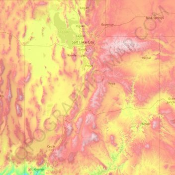
Name: Topografische Karte Utah, Höhe, Relief.
Ort: Utah, United States (36.99781 -114.05285 42.00170 -109.04158)
Durchschnittliche Höhe: 1.876 m
Minimale Höhe: 789 m
Maximale Höhe: 3.986 m
Western Utah is mostly arid desert with a basin and range topography. Small mountain ranges and rugged terrain punctuate the landscape. The Bonneville Salt Flats are an exception, being comparatively flat as a result of once forming the bed of ancient Lake Bonneville. Great Salt Lake, Utah Lake, Sevier Lake, and Rush Lake are all remnants of this ancient freshwater lake, which once covered most of the eastern Great Basin. West of the Great Salt Lake, stretching to the Nevada border, lies the arid Great Salt Lake Desert. One exception to this aridity is Snake Valley, which is (relatively) lush due to large springs and wetlands fed from groundwater derived from snow melt in the Snake Range, Deep Creek Range, and other tall mountains to the west of Snake Valley. Great Basin National Park is just over the Nevada state line in the southern Snake Range. One of western Utah's most impressive, but least visited attractions is Notch Peak, the tallest limestone cliff in North America, located west of Delta.
Andere topografische Karten
Klicken Sie auf eine Karte, um ihre Topografie, ihre Höhe und ihr Relief anzuzeigen.
Los Angeles
Los Angeles, California, United States
Durchschnittliche Höhe: 241 m
Houston
United States > Texas > Harris County
Houston, Harris County, Texas, United States
Durchschnittliche Höhe: 25 m
Spokane
United States > Washington > Spokane County
Spokane, Spokane County, Washington, United States
Durchschnittliche Höhe: 655 m
New Orleans
United States > Louisiana > Orleans Parish
New Orleans, Orleans Parish, Louisiana, United States
Durchschnittliche Höhe: 1 m
Central Park
United States > New York > New York County > New York
Central Park, New York County, New York, United States
Durchschnittliche Höhe: 26 m
Jacksonville
United States > Florida > Duval County
Jacksonville, Duval County, Florida, United States
Durchschnittliche Höhe: 10 m
Brooklyn
United States > New York > New York
Brooklyn, Kings County, New York, United States
Durchschnittliche Höhe: 9 m
Hillsborough County
Hillsborough County, Florida, United States
Durchschnittliche Höhe: 20 m
Albuquerque
United States > New Mexico > Bernalillo County
Albuquerque, Bernalillo County, New Mexico, United States
Durchschnittliche Höhe: 1.688 m
Des Moines
United States > Iowa > Polk County
Des Moines, Polk County, Iowa, United States
Durchschnittliche Höhe: 264 m
Aurora
United States > Colorado > Adams County
Aurora, Adams County, Colorado, United States
Durchschnittliche Höhe: 1.691 m
Kauai
United States > Hawaii > Kauaʻi County
Kauai, Kauaʻi County, Hawaii, United States
Durchschnittliche Höhe: 216 m
Taos
United States > New Mexico > Taos County
Taos, Taos County, New Mexico, United States
Durchschnittliche Höhe: 2.180 m
Lancaster County
Lancaster County, Pennsylvania, United States
Durchschnittliche Höhe: 158 m
Queens County
United States > New York > New York
Queens County, New York, United States
Durchschnittliche Höhe: 11 m
San Mateo County
San Mateo County, California, United States
Durchschnittliche Höhe: 109 m
Madison
United States > Wisconsin > Dane County
Madison, Dane County, Wisconsin, United States
Durchschnittliche Höhe: 284 m
Clark County
Clark County, Washington, United States
Durchschnittliche Höhe: 266 m