
Topografische Karte Fall Creek Falls State Park
Interaktive Karte
Klicken Sie auf die Karte, um die Höhe anzuzeigen.
Über diese Karte
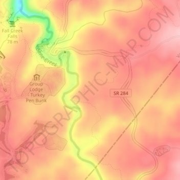
Name: Topografische Karte Fall Creek Falls State Park, Höhe, Relief.
Durchschnittliche Höhe: 524 m
Minimale Höhe: 413 m
Maximale Höhe: 564 m
Just beyond its source, Cane Creek slowly gains strength as it absorbs Meadow Creek and several smaller streams. As the creek enters the gorge, it drops several hundred feet in less than a mile, including 45 feet (14 m) over Cane Creek Cascades and 85 feet (26 m) over Cane Creek Falls. A few hundred meters north of Cane Creek Falls, Rockhouse Creek spills 125 feet (38 m) over a plunge waterfall. Over the next half-mile, Cane Creek absorbs Fall Creek and Piney Creek, both of which enter from smaller gorges to the immediate west. During this stretch, part of the creek disappears underground into limestone sinks and reemerges at a spring known as "Crusher Hole." Cane Creek continues to lose elevation before steadying near its confluence with Dry Fork. Beyond Dry Fork, the creek gradually descends to the Highland Rim, where it empties into the Caney Fork River.
Andere topografische Karten
Klicken Sie auf eine Karte, um ihre Topografie, ihre Höhe und ihr Relief anzuzeigen.
Spencer
United States > Tennessee > Van Buren County
Spencer, Van Buren County, Middle Tennessee, Tennessee, 38585, United States
Durchschnittliche Höhe: 496 m
Welchland
United States > Tennessee > Van Buren County
Welchland, Van Buren County, Tennessee, United States
Durchschnittliche Höhe: 542 m