
Topografische Karte Spencer
Interaktive Karte
Klicken Sie auf die Karte, um die Höhe anzuzeigen.
Über diese Karte
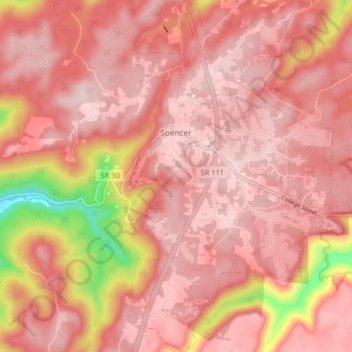
Name: Topografische Karte Spencer, Höhe, Relief.
Durchschnittliche Höhe: 496 m
Minimale Höhe: 277 m
Maximale Höhe: 564 m
Spencer is topographically isolated by the Cumberland Plateau's escarpment to the north and west, the Cane Creek Valley to the east, and the Dry Fork Gulf to the south. Cane Creek, along with its tributary, Dry Fork, slices a narrow valley as it spills down northward toward its confluence with the Caney Fork, effectively dividing the Spencer area from the rest of the plateau. Cane Creek's upper watershed, known for its scenic waterfalls and geological formations, comprises the bulk of Fall Creek Falls State Park.
Andere topografische Karten
Klicken Sie auf eine Karte, um ihre Topografie, ihre Höhe und ihr Relief anzuzeigen.
Fall Creek Falls State Park
United States > Tennessee > Van Buren County
Fall Creek Falls State Park, Van Buren County, Tennessee, United States
Durchschnittliche Höhe: 524 m
Welchland
United States > Tennessee > Van Buren County
Welchland, Van Buren County, Tennessee, United States
Durchschnittliche Höhe: 542 m