
Topografische Karte Thorpe
Interaktive Karte
Klicken Sie auf die Karte, um die Höhe anzuzeigen.
Über diese Karte
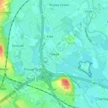
Name: Topografische Karte Thorpe, Höhe, Relief.
Durchschnittliche Höhe: 19 m
Minimale Höhe: 8 m
Maximale Höhe: 71 m
Elevations are modest but not flat, ranging between 14 and 20m Ordnance Datum as much of the area lies on thin alluvium overlying gravel beds laid over millennia by the River Thames which adjoins the traditional parish to the east.
Andere topografische Karten
Klicken Sie auf eine Karte, um ihre Topografie, ihre Höhe und ihr Relief anzuzeigen.
Egham
United Kingdom > England > Surrey > Borough of Runnymede
Egham, Borough of Runnymede, Surrey, England, United Kingdom
Durchschnittliche Höhe: 25 m
Coopers Hill
United Kingdom > England > Surrey > Borough of Runnymede
Coopers Hill, Borough of Runnymede, Surrey, England, TW20 0LL, United Kingdom
Durchschnittliche Höhe: 43 m
Cooper's Hill Slopes
United Kingdom > England > Surrey > Borough of Runnymede > Englefield Green
Cooper's Hill Slopes, Englefield Green, Borough of Runnymede, Surrey, England, TW20 0LG, United Kingdom
Durchschnittliche Höhe: 38 m
Addlestone
United Kingdom > England > Surrey > Borough of Runnymede
Addlestone, Borough of Runnymede, Surrey, England, United Kingdom
Durchschnittliche Höhe: 18 m
Pooley Green
United Kingdom > England > Surrey > Borough of Runnymede
Pooley Green, Borough of Runnymede, Surrey, England, TW20 8AR, United Kingdom
Durchschnittliche Höhe: 17 m
Lyne
United Kingdom > England > Surrey > Borough of Runnymede
Lyne, Borough of Runnymede, Surrey, England, KT16 0BL, United Kingdom
Durchschnittliche Höhe: 33 m
Wentworth
United Kingdom > England > Surrey > Borough of Runnymede
Wentworth, Borough of Runnymede, Surrey, England, GU25 4NP, United Kingdom
Durchschnittliche Höhe: 50 m
Englefield Green
United Kingdom > England > Surrey > Borough of Runnymede
Englefield Green, Borough of Runnymede, Surrey, England, TW20 0PQ, United Kingdom
Durchschnittliche Höhe: 48 m
Egham Hythe
United Kingdom > England > Surrey > Borough of Runnymede
Egham Hythe, Borough of Runnymede, Surrey, England, United Kingdom
Durchschnittliche Höhe: 16 m
Chertsey
United Kingdom > England > Surrey > Borough of Runnymede
Chertsey, Borough of Runnymede, Surrey, England, United Kingdom
Durchschnittliche Höhe: 17 m
Virginia Water
United Kingdom > England > Surrey > Borough of Runnymede
Virginia Water, Borough of Runnymede, Surrey, England, GU25 4DL, United Kingdom
Durchschnittliche Höhe: 36 m
Egham Wick
United Kingdom > England > Surrey > Borough of Runnymede > Englefield Green
Egham Wick, Englefield Green, Borough of Runnymede, Surrey, England, TW20 0HN, United Kingdom
Durchschnittliche Höhe: 55 m
Chobham Common
United Kingdom > England > Surrey > Borough of Runnymede > Longcross
Chobham Common, Horse exercise track, Longcross, Borough of Runnymede, Surrey, England, GU24 8HJ, United Kingdom
Durchschnittliche Höhe: 45 m
Ottershaw
United Kingdom > England > Surrey > Borough of Runnymede
Ottershaw, Borough of Runnymede, Surrey, England, KT16 0HN, United Kingdom
Durchschnittliche Höhe: 33 m