Geolokalisieren
👉 Easily get elevation data in JSON, GeoTIFF and KML formats using Elevation API
Vielen Dank für die Unterstützung dieser Website ❤️
Spenden

Rüste dich für dein nächstes Abenteuer:

Als Amazon-Partner verdient diese Website an qualifizierten Käufen, ohne zusätzliche Kosten für Sie.

Topografische Karte Madison

Klicken Sie auf die Karte, um die Höhe anzuzeigen.

Madison

The city is sometimes described as The City of Four Lakes, comprising the four successive lakes of the Yahara River: Lake Mendota ("Fourth Lake"), Lake Monona ("Third Lake"), Lake Waubesa ("Second Lake") and Lake Kegonsa ("First Lake"), although Waubesa and Kegonsa are not actually in Madison, but just south of it. A fifth smaller lake, Lake Wingra, is within the city as well; it is connected to the Yahara River chain by Wingra Creek. The Yahara flows into the Rock River, which flows into the Mississippi River. Downtown Madison is located on an isthmus between Lakes Mendota and Monona. The city's trademark of "Lake, City, Lake" reflects this geography. The city's lowest elevation is the intersection of Regas Road and Corporate Drive on the east side, at 836.9 ft (255.1 m). The highest elevation is located along Pleasant View Road on the far west side of the city, atop a portion of a terminal moraine of the Green Bay Lobe of the Wisconsin glaciation, at 1,190 ft (360 m).

Wikipedia (CC-BY-SA 3.0)

Über diese Karte

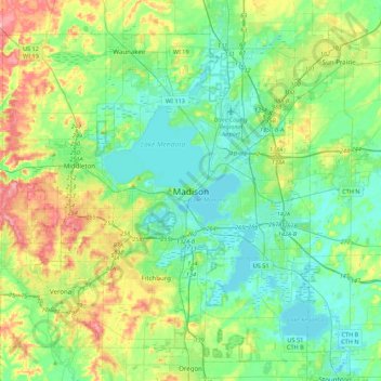
Name: Topografische Karte Madison, Höhe, Relief.

Ort: Madison, Dane County, Wisconsin, 53703, United States (42.91476 -89.54376 43.23476 -89.22376)

Durchschnittliche Höhe: 289 m

Minimale Höhe: 255 m

Maximale Höhe: 377 m

👉 Easily get elevation data in JSON, GeoTIFF and KML formats using Elevation API
Vielen Dank für die Unterstützung dieser Website ❤️
Spenden

Rüste dich für dein nächstes Abenteuer:

Als Amazon-Partner verdient diese Website an qualifizierten Käufen, ohne zusätzliche Kosten für Sie.

Andere topografische Karten

Klicken Sie auf eine Karte, um ihre Topografie, ihre Höhe und ihr Relief anzuzeigen.

DeForest

United States > Wisconsin > Dane County

Durchschnittliche Höhe: 290 m

Monona

United States > Wisconsin > Dane County

Durchschnittliche Höhe: 264 m

Town of Mazomanie

United States > Wisconsin > Dane County

Durchschnittliche Höhe: 246 m

Capitol Square

United States > Wisconsin > Dane County > Madison

Durchschnittliche Höhe: 262 m

Camrock County Park

United States > Wisconsin > Dane County > Rockdale

Durchschnittliche Höhe: 264 m

Town of Oregon

United States > Wisconsin > Dane County

Durchschnittliche Höhe: 298 m

Vielen Dank für die Unterstützung dieser Website ❤️
Spenden

Rüste dich für dein nächstes Abenteuer:

Als Amazon-Partner verdient diese Website an qualifizierten Käufen, ohne zusätzliche Kosten für Sie.

Cambridge

United States > Wisconsin > Dane County

Durchschnittliche Höhe: 262 m

Blooming Grove

United States > Wisconsin > Dane County

Durchschnittliche Höhe: 266 m

Windsor

United States > Wisconsin > Dane County

Durchschnittliche Höhe: 293 m

Town of Dunkirk

United States > Wisconsin > Dane County

Durchschnittliche Höhe: 269 m

Town of Blue Mounds

United States > Wisconsin > Dane County

Durchschnittliche Höhe: 352 m

Belleville

United States > Wisconsin > Dane County

Durchschnittliche Höhe: 269 m

Vielen Dank für die Unterstützung dieser Website ❤️
Spenden

Rüste dich für dein nächstes Abenteuer:

Als Amazon-Partner verdient diese Website an qualifizierten Käufen, ohne zusätzliche Kosten für Sie.

Town of Bristol

United States > Wisconsin > Dane County

Durchschnittliche Höhe: 287 m

Village of Cottage Grove

United States > Wisconsin > Dane County

Durchschnittliche Höhe: 278 m

Dane

United States > Wisconsin > Dane County

Durchschnittliche Höhe: 327 m

Maple Bluff

United States > Wisconsin > Dane County

Durchschnittliche Höhe: 263 m

Vielen Dank für die Unterstützung dieser Website ❤️
Spenden

Rüste dich für dein nächstes Abenteuer:

Als Amazon-Partner verdient diese Website an qualifizierten Käufen, ohne zusätzliche Kosten für Sie.

Rockdale

United States > Wisconsin > Dane County

Durchschnittliche Höhe: 266 m

Town of Springfield

United States > Wisconsin > Dane County

Durchschnittliche Höhe: 308 m

Town of Roxbury

United States > Wisconsin > Dane County

Durchschnittliche Höhe: 282 m

Fitchburg Center Park

United States > Wisconsin > Dane County > Fitchburg

Durchschnittliche Höhe: 299 m

Town of Pleasant Springs

United States > Wisconsin > Dane County

Durchschnittliche Höhe: 277 m

Stoughton

United States > Wisconsin > Dane County

Durchschnittliche Höhe: 269 m

Monona Bay

United States > Wisconsin > Dane County > Madison

Durchschnittliche Höhe: 266 m

Deerfield

United States > Wisconsin > Dane County

Durchschnittliche Höhe: 270 m

Town of Rutland

United States > Wisconsin > Dane County

Durchschnittliche Höhe: 293 m

Town of Albion

United States > Wisconsin > Dane County

Durchschnittliche Höhe: 263 m

Rüste dich für dein nächstes Abenteuer:

🏕️Zelte - Wetterfeste Zelte für Camping und Trekking
🪓Eispickel - Sicherheit auf Gletschern
🏕️Trekkingzelte - Leichte Zelte für Rucksacktouren
🧺Isolierendes Sitzkissen - Bequeme und warme Pause auf Steinen oder feuchtem Boden
Höhenmesser - Messung der Höhe im Gebirge

Als Amazon-Partner verdient diese Website an qualifizierten Käufen, ohne zusätzliche Kosten für Sie.