Topografische Karte Dane
Klicken Sie auf die Karte, um die Höhe anzuzeigen.
Über diese Karte
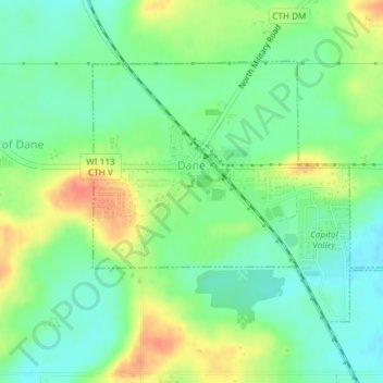
Name: Topografische Karte Dane, Höhe, Relief.
Ort: Dane, Dane County, Wisconsin, United States (43.23953 -89.51109 43.25789 -89.48133)
Durchschnittliche Höhe: 327 m
Minimale Höhe: 308 m
Maximale Höhe: 355 m
Andere topografische Karten
Klicken Sie auf eine Karte, um ihre Topografie, ihre Höhe und ihr Relief anzuzeigen.
Madison
United States > Wisconsin > Dane County
The city is sometimes described as The City of Four Lakes, comprising the four successive lakes of the Yahara River: Lake Mendota ("Fourth Lake"), Lake Monona ("Third Lake"), Lake Waubesa ("Second Lake") and Lake Kegonsa ("First Lake"), although Waubesa and Kegonsa are not actually in Madison, but just south…
Durchschnittliche Höhe: 289 m
Glacial Valley Park
United States > Wisconsin > Dane County > Village of Cross Plains
Durchschnittliche Höhe: 287 m

Indian Lake County Park
United States > Wisconsin > Dane County > Town of Berry
Durchschnittliche Höhe: 316 m

Taylors Corners
United States > Wisconsin > Dane County > Village of Cottage Grove
Durchschnittliche Höhe: 277 m
Kegonsa
United States > Wisconsin > Dane County > Town of Pleasant Springs
Durchschnittliche Höhe: 267 m
Pine Bluff
United States > Wisconsin > Dane County > Town of Cross Plains
Durchschnittliche Höhe: 320 m
Seminary Springs
United States > Wisconsin > Dane County > Town of Burke
Durchschnittliche Höhe: 294 m
Springfield Corners
United States > Wisconsin > Dane County > Town of Springfield
Durchschnittliche Höhe: 317 m
West Middleton
United States > Wisconsin > Dane County > Town of Middleton
Durchschnittliche Höhe: 339 m
Fitchburg Center Park
United States > Wisconsin > Dane County > Fitchburg
Durchschnittliche Höhe: 299 m