
Topografische Karte Nanda Devi
Interaktive Karte
Klicken Sie auf die Karte, um die Höhe anzuzeigen.
Über diese Karte
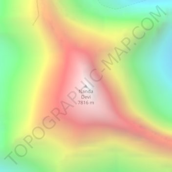
Name: Topografische Karte Nanda Devi, Höhe, Relief.
Durchschnittliche Höhe: 6.567 m
Minimale Höhe: 5.371 m
Maximale Höhe: 7.782 m
Andere topografische Karten
Klicken Sie auf eine Karte, um ihre Topografie, ihre Höhe und ihr Relief anzuzeigen.
Modera
India > Uttarakhand > Joshimath Tehsil
Modera, Joshimath Tehsil, Chamoli District, Uttarakhand, India
Durchschnittliche Höhe: 2.881 m
Mana
India > Uttarakhand > Joshimath Tehsil
Mana, Joshimath Tehsil, Chamoli District, Uttarakhand, India
Durchschnittliche Höhe: 4.959 m
Badrinath
India > Uttarakhand > Joshimath Tehsil > Badrinath
Badrinath, Joshimath Tehsil, Chamoli district, Uttarakhand, India
Durchschnittliche Höhe: 4.052 m