
Topografische Karte Modera
Interaktive Karte
Klicken Sie auf die Karte, um die Höhe anzuzeigen.
Über diese Karte
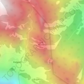
Name: Topografische Karte Modera, Höhe, Relief.
Ort: Modera, Joshimath Tehsil, Chamoli District, Uttarakhand, India (30.52291 79.42418 30.52301 79.42428)
Durchschnittliche Höhe: 2.881 m
Minimale Höhe: 1.910 m
Maximale Höhe: 3.615 m
Andere topografische Karten
Klicken Sie auf eine Karte, um ihre Topografie, ihre Höhe und ihr Relief anzuzeigen.
Mana
India > Uttarakhand > Joshimath Tehsil
Mana, Joshimath Tehsil, Chamoli District, Uttarakhand, India
Durchschnittliche Höhe: 4.959 m
Badrinath
India > Uttarakhand > Joshimath Tehsil > Badrinath
Badrinath, Joshimath Tehsil, Chamoli district, Uttarakhand, India
Durchschnittliche Höhe: 4.052 m
Nanda Devi
India > Uttarakhand > Joshimath Tehsil
Nanda Devi, Joshimath Tehsil, Chamoli district, Uttarakhand, India
Durchschnittliche Höhe: 6.567 m