
Topografische Karte Santa Cruz
Klicken Sie auf die Karte, um die Höhe anzuzeigen.
Über diese Karte
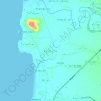
Name: Topografische Karte Santa Cruz, Höhe, Relief.
Ort: Santa Cruz, La Union, Ilocos Region, 2525, Philippines (16.72127 120.32801 16.76127 120.36801)
Durchschnittliche Höhe: 7 m
Minimale Höhe: 0 m
Maximale Höhe: 71 m
Andere topografische Karten
Klicken Sie auf eine Karte, um ihre Topografie, ihre Höhe und ihr Relief anzuzeigen.
Rosario
The topography of Rosario is characterized by a valley with mountainous terrain, predominantly shaped by the sharply sloping mountains of the Cordillera Central range, which runs parallel to the coast of the South China Sea. To the west, the land features narrow plains and valleys, interspersed with shallow…
Durchschnittliche Höhe: 337 m
Tubao
Rural topography is seventy percent (70%) alluvial plains and thirty percent (30%) uplands. Highest portion is located in Barangay Rizal, which is more than 500 metres (1,600 ft) above sea level along the foothill of Cordillera Central. Flat lands are found in the middle portion of the town, in between its…
Durchschnittliche Höhe: 84 m
Agoo-Damortis Protected Landscape and Seascape
Philippines > La Union > Santo Tomas
Durchschnittliche Höhe: 9 m
Rosario
The topography of Rosario is characterized by a valley with mountainous terrain, predominantly shaped by the sharply sloping mountains of the Cordillera Central range, which runs parallel to the coast of the South China Sea. To the west, the land features narrow plains and valleys, interspersed with shallow…
Durchschnittliche Höhe: 337 m
Aringay
Aringay is a coastal municipality in La Union with a land area of 84.54 square kilometers (32.64 square miles), comprising 5.64% of La Union's total area. The municipality's topography features hilly and mountainous terrains that rise gradually eastward from the coastal plains. Situated at the foothills of the…
Durchschnittliche Höhe: 90 m
Agoo
The town's topography is characterized by hilly and mountainous terrain that rises gradually eastward from the coastal plains. Its landscape is also marked by wetlands, scrublands, and grasslands. Mount Katayagan, the highest peak in the town, provides a watershed that supplies water for irrigation and…
Durchschnittliche Höhe: 57 m
Pugo
The town's topography is predominantly hilly and mountainous, as it is nestled at the foothills of the Mount Santo Tomas (Cordillera Central) a stratovolcano. Lush and peaceful forests cover much of the area, with the terrain rising gradually eastward. Rural areas in the town are characterized by alluvial…
Durchschnittliche Höhe: 328 m
Tubao
Rural topography is seventy percent (70%) alluvial plains and thirty percent (30%) uplands. Highest portion is located in Barangay Rizal, which is more than 500 metres (1,600 ft) above sea level along the foothill of Cordillera Central. Flat lands are found in the middle portion of the town, in between its…
Durchschnittliche Höhe: 84 m
Rosario
The topography of Rosario is characterized by a valley with mountainous terrain, predominantly shaped by the sharply sloping mountains of the Cordillera Central range, which runs parallel to the coast of the South China Sea. To the west, the land features narrow plains and valleys, interspersed with shallow…
Durchschnittliche Höhe: 337 m
Agoo
The town’s topography is characterized by hilly and mountainous terrain that rises gradually eastward from the coastal plains. Its landscape is also marked by wetlands, scrublands, and grasslands. Mount Katayagan, the highest peak in the town, provides a watershed that supplies water for irrigation and…
Durchschnittliche Höhe: 57 m
San Fernando
The city's topography is characterized by predominantly hilly terrain that gradually rises eastward from the coastal plains. It is traversed by several rivers and creeks, including the Carlatan and Catbangen rivers. The landscape also features scrublands, grasslands, wetlands, and is in proximity to seven…
Durchschnittliche Höhe: 68 m