
Topografische Karte Agoo-Damortis Protected Landscape and Seascape
Interaktive Karte
Klicken Sie auf die Karte, um die Höhe anzuzeigen.
Über diese Karte
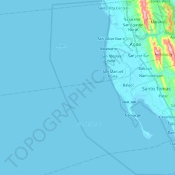
Name: Topografische Karte Agoo-Damortis Protected Landscape and Seascape, Höhe, Relief.
Durchschnittliche Höhe: 9 m
Minimale Höhe: -1 m
Maximale Höhe: 246 m
Andere topografische Karten
Klicken Sie auf eine Karte, um ihre Topografie, ihre Höhe und ihr Relief anzuzeigen.
Sungyot Island
Philippines > La Union > Santo Tomas
Sungyot Island, Santo Tomas, La Union, Ilocos Region, Philippines
Durchschnittliche Höhe: 0 m
Cupang
Philippines > La Union > Santo Tomas
Cupang, Santo Tomas, La Union, Ilocos Region, Philippines
Durchschnittliche Höhe: 23 m
Tubod
Philippines > La Union > Santo Tomas
Tubod, Santo Tomas, La Union, Ilocos Region, Philippines
Durchschnittliche Höhe: 24 m
Damortis
Philippines > La Union > Santo Tomas
Damortis, Santo Tomas, La Union, Philippines
Durchschnittliche Höhe: 25 m
Parasapas
Philippines > La Union > Santo Tomas
Parasapas, Santo Tomas, La Union, Ilocos Region, 2508, Philippines
Durchschnittliche Höhe: 202 m
Santo Tomas
Philippines > La Union > Santo Tomas
Santo Tomas, La Union, Ilocos Region, 2505, Philippines
Durchschnittliche Höhe: 40 m