
Topografische Karte Bristol
Interaktive Karte
Klicken Sie auf die Karte, um die Höhe anzuzeigen.
Über diese Karte
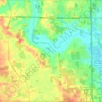
Name: Topografische Karte Bristol, Höhe, Relief.
Ort: Bristol, Kenosha County, Wisconsin, 53104, United States (42.49468 -88.06998 42.58304 -87.95034)
Durchschnittliche Höhe: 226 m
Minimale Höhe: 203 m
Maximale Höhe: 253 m
Andere topografische Karten
Klicken Sie auf eine Karte, um ihre Topografie, ihre Höhe und ihr Relief anzuzeigen.
Town of Wheatland
United States > Wisconsin > Kenosha County
Town of Wheatland, Kenosha County, Wisconsin, 53152, United States
Durchschnittliche Höhe: 244 m
Town of Randall
United States > Wisconsin > Kenosha County
Town of Randall, Kenosha County, Wisconsin, United States
Durchschnittliche Höhe: 259 m
Village of Somers
United States > Wisconsin > Kenosha County
Village of Somers, Kenosha County, Wisconsin, United States
Durchschnittliche Höhe: 206 m
Paddock Lake
United States > Wisconsin > Kenosha County
Paddock Lake, Kenosha County, Wisconsin, 53168, United States
Durchschnittliche Höhe: 244 m
Kenosha
United States > Wisconsin > Kenosha County
Kenosha, Kenosha County, Wisconsin, United States
Durchschnittliche Höhe: 190 m
Pleasant Prairie
United States > Wisconsin > Kenosha County
Pleasant Prairie, Kenosha County, Wisconsin, 53158, United States
Durchschnittliche Höhe: 199 m
Salem Lakes
United States > Wisconsin > Kenosha County
Salem Lakes, Kenosha County, Wisconsin, United States
Durchschnittliche Höhe: 241 m