
Topografische Karte Newbury
Interaktive Karte
Klicken Sie auf die Karte, um die Höhe anzuzeigen.
Über diese Karte
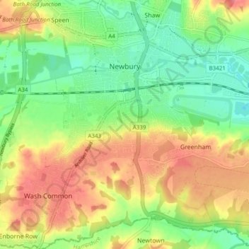
Name: Topografische Karte Newbury, Höhe, Relief.
Ort: Newbury, West Berkshire, England, United Kingdom (51.36711 -1.35315 51.41456 -1.28819)
Durchschnittliche Höhe: 97 m
Minimale Höhe: 64 m
Maximale Höhe: 135 m
Elevations vary from a minimum of 72 m above mean sea level to 122 m at Wash Common. Elevations reach 150–200 m in the directly adjoining hills. The River Kennet and the Kennet and Avon Canal flow east through the centre of the town to reach the Thames at Reading, while the River Lambourn (beside which is the country's largest horse-training paddocks in the Valley of the Lambourn Downs) partly forms its northern boundary, ending in the town. A tributary that is smaller still, the River Enborne, forms the southern boundary (and also the county boundary with Hampshire).
Andere topografische Karten
Klicken Sie auf eine Karte, um ihre Topografie, ihre Höhe und ihr Relief anzuzeigen.
Combe
United Kingdom > England > West Berkshire
Combe, West Berkshire, England, United Kingdom
Durchschnittliche Höhe: 215 m
Berkshire
United Kingdom > England > West Berkshire
Berkshire, West Berkshire, England, United Kingdom
Durchschnittliche Höhe: 100 m
Winterbourne
United Kingdom > England > West Berkshire
Winterbourne, West Berkshire, England, United Kingdom
Durchschnittliche Höhe: 120 m
Reading
United Kingdom > England > West Berkshire > Reading
Reading, West Berkshire, South East England, England, RG1 1DA, United Kingdom
Durchschnittliche Höhe: 56 m
Mortimer
United Kingdom > England > West Berkshire > Mortimer
Mortimer, Stratfield Mortimer, West Berkshire, South East England, England, RG7 3RD, United Kingdom
Durchschnittliche Höhe: 80 m