
Topografische Karte Berkshire
Interaktive Karte
Klicken Sie auf die Karte, um die Höhe anzuzeigen.
Über diese Karte
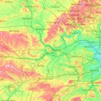
Name: Topografische Karte Berkshire, Höhe, Relief.
Ort: Berkshire, West Berkshire, England, United Kingdom (51.32896 -1.58809 51.57783 -0.49004)
Durchschnittliche Höhe: 100 m
Minimale Höhe: 11 m
Maximale Höhe: 294 m
All of the county is drained by the Thames. Berkshire divides into two topological (and associated geological) sections: east and west of Reading. North-east Berkshire has the low calciferous (limestone) m-shaped bends of the Thames south of which is a broader, clayey, gravelly former watery plain or belt from Earley to Windsor and beyond, south, are parcels and belts of uneroded higher sands, flints, shingles and lightly acid soil and in the north of the Bagshot Formation, north of Surrey and Hampshire. Swinley Forest (also known as Bracknell Forest), Windsor Great Park, Crowthorne and Stratfield Saye Woods have many pine, silver birch, and other lightly acid-soil trees. East of the grassy and wooded bends a large minority of East Berkshire's land mirrors the clay belt, being of low elevation and on the left (north) bank of the Thames: Slough, Eton, Eton Wick, Wraysbury, Horton, and Datchet. In the heart of the county Reading's northern suburb Caversham is also on that bank, but rises steeply into the Chiltern Hills.
Andere topografische Karten
Klicken Sie auf eine Karte, um ihre Topografie, ihre Höhe und ihr Relief anzuzeigen.
Combe
United Kingdom > England > West Berkshire
Combe, West Berkshire, England, United Kingdom
Durchschnittliche Höhe: 215 m
Newbury
United Kingdom > England > West Berkshire
Newbury, West Berkshire, England, United Kingdom
Durchschnittliche Höhe: 97 m
Winterbourne
United Kingdom > England > West Berkshire
Winterbourne, West Berkshire, England, United Kingdom
Durchschnittliche Höhe: 120 m
Reading
United Kingdom > England > West Berkshire > Reading
Reading, West Berkshire, South East England, England, RG1 1DA, United Kingdom
Durchschnittliche Höhe: 56 m
Mortimer
United Kingdom > England > West Berkshire > Mortimer
Mortimer, Stratfield Mortimer, West Berkshire, South East England, England, RG7 3RD, United Kingdom
Durchschnittliche Höhe: 80 m