
Topografische Karte Sierra de Guadarrama
Interaktive Karte
Klicken Sie auf die Karte, um die Höhe anzuzeigen.
Sierra de Guadarrama
The range runs southwest–northeast, extending from the province of Ávila in the southwest, through the Community of Madrid, to the province of Segovia in the northeast. The range measures approximately 80 kilometres (50 mi) in length. Its highest peak is Peñalara, 2,428 metres (7,966 ft) in elevation.
Über diese Karte
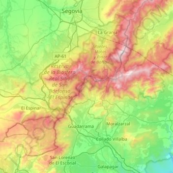
Name: Topografische Karte Sierra de Guadarrama, Höhe, Relief.
Ort: Sierra de Guadarrama, Ávila, Community of Madrid, Spain (40.56181 -4.22218 40.97292 -3.88114)
Durchschnittliche Höhe: 1.235 m
Minimale Höhe: 627 m
Maximale Höhe: 2.403 m
Andere topografische Karten
Klicken Sie auf eine Karte, um ihre Topografie, ihre Höhe und ihr Relief anzuzeigen.
Madrid
Madrid lies in the centre of the Iberian peninsula on the southern Meseta Central, 60 km south of the Guadarrama mountain range and straddling the Jarama and Manzanares river sub-drainage basins, in the wider Tagus River catchment area. With an average altitude of 650 metres (2,130 ft), Madrid is the second…
Durchschnittliche Höhe: 671 m
San Lorenzo de El Escorial
San Lorenzo de El Escorial is located on the southern slopes of the Mount Abantos (elevation 1753 m). The average altitude of the municipality is 1,032 metres (3,386 ft), and most of the urban area is above 1,000 metres (3,300 ft). The hamlet initially sprang up around Monastery of El Escorial, gradually…
Durchschnittliche Höhe: 1.179 m
Madrid
Madrid lies in the centre of the Iberian peninsula on the southern Meseta Central, 60 km south of the Guadarrama mountain range and straddling the Jarama and Manzanares river sub-drainage basins, in the wider Tagus River catchment area. With an average altitude of 650 metres (2,130 ft), Madrid is the second…
Durchschnittliche Höhe: 671 m
La Maliciosa
Spain > Community of Madrid > Navacerrada
La Maliciosa is one of the most important and highest mountains of the Sierra de Guadarrama, a mountainous formation belonging to the Sistema Central. It has an altitude of 2227m above sea level and is located in the northwest of the Community of Madrid, in Spain, rising between La Pedriza, which lies to the…
Durchschnittliche Höhe: 1.856 m
Madrid
Madrid lies in the centre of the Iberian peninsula on the southern Meseta Central, 60 km south of the Guadarrama mountain range and straddling the Jarama and Manzanares river sub-drainage basins, in the wider Tagus River catchment area. With an average altitude of 650 m (2,130 ft), Madrid is the second highest…
Durchschnittliche Höhe: 671 m
Alcalá de Henares
Standing at an average altitude of 654 m, and occupying some 88 km2; the city was for a long time contained in between the Henares to the South and the Madrid-Barcelona railway to the North. However, the increasing population brought on the sprawl of the urbanised area to the area located in between the…
Durchschnittliche Höhe: 642 m
Somosierra
Somosierra is a municipality in the Community of Madrid, Spain, located at 83 km north of Madrid, in the mountain pass with the same name, at an elevation of 1433 metres above sea level, being the northernmost town of Community of Madrid. The Battle of Somosierra was fought here in 1808 during the Napoleonic…
Durchschnittliche Höhe: 1.560 m
Madrid
Madrid lies in the centre of the Iberian peninsula on the southern Meseta Central, 60 km south of the Guadarrama mountain range and straddling the Jarama and Manzanares river sub-drainage basins, in the wider Tagus River catchment area. With an average altitude of 650 m (2,130 ft), Madrid is the second highest…
Durchschnittliche Höhe: 671 m
Torrelodones
It lies at an average altitude of 845 meters. According to the 2022 census, 24,775 people live in the municipality, distributed among seven towns.
Durchschnittliche Höhe: 819 m
Alcalá de Henares
Standing at an average altitude of 654 m, and occupying some 88 km2; the city was for a long time contained in between the Henares to the South and the Madrid-Barcelona railway to the North. However, the increasing population brought on the sprawl of the urbanised area to the area located in between the…
Durchschnittliche Höhe: 642 m
Villanueva de la Cañada
Geologically, its limits form part of the depression of the Tajo and it is defined by the existence of many alluvial fields, with an average elevation of 652 metres.
Durchschnittliche Höhe: 641 m
Valdemoro
The highest point of elevation in the municipal district is the Cerro de la Mira ("Hill of La Mira") at 712 meters. The lowest point of elevation is the La Cañada stream at 543 meters. The average altitude of Valdemoro is 615 meters above sea level. The ground slopes in an Easterly direction, averaging a 3%…
Durchschnittliche Höhe: 623 m
Parla
Its elevation is 648.5 meters above sea level.
Durchschnittliche Höhe: 637 m
Alcalá de Henares
Standing at an average altitude of 654 m, and occupying some 88 km2; the city was for a long time contained in between the Henares to the South and the Madrid-Barcelona railway to the North. However, the increasing population brought on the sprawl of the urbanised area to the area located in between the…
Durchschnittliche Höhe: 642 m
Arciprestazgo de Alcalá Sur
Spain > Community of Madrid > Alcalá de Henares
Standing at an average altitude of 654 m, and occupying some 88 km2; the city was for a long time contained in between the Henares to the South and the Madrid-Barcelona railway to the North. However, the increasing population brought on the sprawl of the urbanised area to the area located in between the…
Durchschnittliche Höhe: 685 m
Madrid
Madrid lies in the centre of the Iberian peninsula on the southern Meseta Central, 60 km south of the Guadarrama mountain range and straddling the Jarama and Manzanares river sub-drainage basins, in the wider Tagus River catchment area. With an average altitude of 650 m (2,130 ft), Madrid is the second highest…
Durchschnittliche Höhe: 671 m
Santa María de la Alameda
Spain > Community of Madrid > Sierra Oeste
Originally a group of cattle-raising hamlets, the municipality comprises different settlements: Las Herreras, El Pimpollar, La Hoya, Navalespino, La Paradilla, Robledondo, Santa María de la Alameda and Santa María Estación. In time, the nucleus of "Santa María Estación", developed around the railway…
Durchschnittliche Höhe: 1.339 m
Getafe
Getafe is located in the southern zone of the autonomous community of Madrid, Spain, in southwestern Europe. It is physically located in the centre of the Iberian Peninsula, north of the Southern Submeseta (part of the Meseta Central), in the Manzanares River basin. Its elevation is 610 – 640 meters above…
Durchschnittliche Höhe: 631 m
Loma del Rellano
Spain > Community of Madrid > Área metropolitana de Madrid y Corredor del Henares > San Sebastián de los Reyes
Durchschnittliche Höhe: 687 m
Tres Cantos
Spain > Community of Madrid > Área metropolitana de Madrid y Corredor del Henares > Tres Cantos
Tres Cantos was built on former rural lands, about halfway from the northern outskirts of suburban Madrid to the Guadarrama mountain range, which are frequently snow-capped in winter. It lies in a slight valley formed with two eastwards-flowing creeks, bounded to the south by a higher plateau leading to…
Durchschnittliche Höhe: 720 m
Cuenca del Medio Jarama
Spain > Community of Madrid > Cuenca del Medio Jarama
Durchschnittliche Höhe: 717 m
Alcorcón
The municipality, largely flat, lies at an average altitude of 711 metres above sea level, with the highest point being El Ventorro del Cano (741 m), located in the north of the municipality.
Durchschnittliche Höhe: 692 m
Talamanca de Jarama
Spain > Community of Madrid > Cuenca del Medio Jarama
Durchschnittliche Höhe: 713 m
Alcalá de Henares
Standing at an average altitude of 654 m, and occupying some 88 km2; the city was for a long time contained in between the Henares to the South and the Madrid-Barcelona railway to the North. However, the increasing population brought on the sprawl of the urbanised area to the area located in between the…
Durchschnittliche Höhe: 642 m
Carabanchel
Spain > Community of Madrid > Área metropolitana de Madrid y Corredor del Henares > Madrid
Durchschnittliche Höhe: 640 m
Community of Madrid
Most of province lies between 600 and 1,000 m above sea level. However, there the altitude ranges from the 2,428 metres of Peñalara and the 430 metres of the Alberche river when it leaves Villa del Prado into the province of Toledo. Other considerable heights, as well as being famous, are the Bola del Mundo…
Durchschnittliche Höhe: 852 m
Fresnedillas de la Oliva
Spain > Community of Madrid > Fresnedillas de la Oliva
Durchschnittliche Höhe: 859 m
Área metropolitana de Madrid y Corredor del Henares
Durchschnittliche Höhe: 678 m
San Sebastián de los Reyes
Spain > Community of Madrid > Área metropolitana de Madrid y Corredor del Henares > San Sebastián de los Reyes
Durchschnittliche Höhe: 658 m
San Martín de la Vega
Spain > Community of Madrid > Las Vegas > San Martín de la Vega
Durchschnittliche Höhe: 585 m
Fuenlabrada
Spain > Community of Madrid > Área metropolitana de Madrid y Corredor del Henares > Fuenlabrada
The founding of the village of Fuenlabrada has been tentatively traced to the late 14th century, populated by the dwellers of the nearby settlements of Loranca, Albas and Fregacedos, which had been simultaneously depopulated. The first mention of Fuenlabrada, which by the early 16th century was part of the…
Durchschnittliche Höhe: 630 m
Sevilla la Nueva
Spain > Community of Madrid > Comarca Sur > Sevilla la Nueva
Durchschnittliche Höhe: 637 m
Valdemorillo
Spain > Community of Madrid > Cuenca del Guadarrama > Valdemorillo
Durchschnittliche Höhe: 799 m
Algete
The altitude of the municipality varies between 600 and 780 metres above sea level. It has average winter temperatures lower than those of the capital of Madrid. The inhabited areas can be divided into two categories: residential developments and the historic centre.
Durchschnittliche Höhe: 679 m