
Spenden
Rüste dich für dein nächstes Abenteuer:
Als Amazon-Partner verdient diese Website an qualifizierten Käufen, ohne zusätzliche Kosten für Sie.
Topografische Karte Selva di Cadore
Klicken Sie auf die Karte, um die Höhe anzuzeigen.
Spenden
Rüste dich für dein nächstes Abenteuer:
Als Amazon-Partner verdient diese Website an qualifizierten Käufen, ohne zusätzliche Kosten für Sie.
Über diese Karte
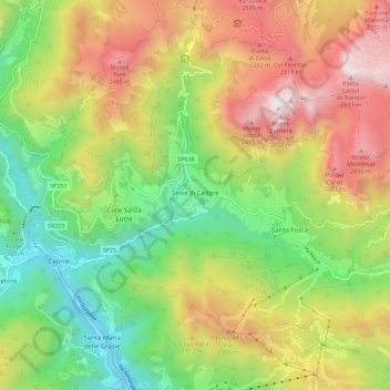
Name: Topografische Karte Selva di Cadore, Höhe, Relief.
Ort: Selva di Cadore, Belluno, Veneto, Italy (46.41962 12.00574 46.48202 12.11795)
Durchschnittliche Höhe: 1.696 m
Minimale Höhe: 969 m
Maximale Höhe: 2.636 m
Spenden
Rüste dich für dein nächstes Abenteuer:
Als Amazon-Partner verdient diese Website an qualifizierten Käufen, ohne zusätzliche Kosten für Sie.
Andere topografische Karten
Klicken Sie auf eine Karte, um ihre Topografie, ihre Höhe und ihr Relief anzuzeigen.
Spenden
Rüste dich für dein nächstes Abenteuer:
Als Amazon-Partner verdient diese Website an qualifizierten Käufen, ohne zusätzliche Kosten für Sie.
Spenden
Rüste dich für dein nächstes Abenteuer:
Als Amazon-Partner verdient diese Website an qualifizierten Käufen, ohne zusätzliche Kosten für Sie.
Pieve di Cadore
Italy > Veneto > Belluno > Pieve di Cadore > Pieve di Cadore
Durchschnittliche Höhe: 1.116 m
Spenden
Rüste dich für dein nächstes Abenteuer:
Als Amazon-Partner verdient diese Website an qualifizierten Käufen, ohne zusätzliche Kosten für Sie.
Spenden
Rüste dich für dein nächstes Abenteuer:
Als Amazon-Partner verdient diese Website an qualifizierten Käufen, ohne zusätzliche Kosten für Sie.
Spenden
Rüste dich für dein nächstes Abenteuer:
Als Amazon-Partner verdient diese Website an qualifizierten Käufen, ohne zusätzliche Kosten für Sie.
Gruppo del Pomagagnon
Italy > Veneto > Belluno > Cortina d'Ampezzo
Pomagagnon is a mountain of the Dolomites in Belluno, northern Italy. It has an elevation of 2,450 metres (8,038 ft) and is the southernmost mountain of the Cristallo Group, towering 1,200 metres (3,937 ft) over the resort of Cortina d'Ampezzo. The mountain is part of the "Natural Park of the Ampezzo…
Durchschnittliche Höhe: 1.758 m
Spenden
Rüste dich für dein nächstes Abenteuer:
Als Amazon-Partner verdient diese Website an qualifizierten Käufen, ohne zusätzliche Kosten für Sie.
Zwölferkofel - Croda dei Toni
Italy > Veneto > Belluno > Auronzo di Cadore
Durchschnittliche Höhe: 2.367 m