
Topografische Karte Diamondhead
Interaktive Karte
Klicken Sie auf die Karte, um die Höhe anzuzeigen.
Über diese Karte
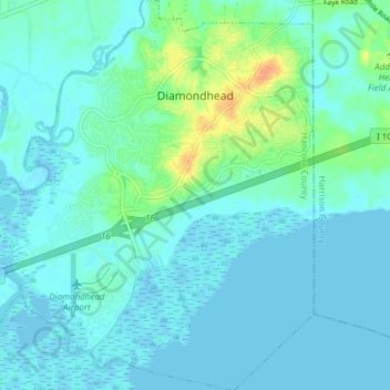
Name: Topografische Karte Diamondhead, Höhe, Relief.
Durchschnittliche Höhe: 6 m
Minimale Höhe: -4 m
Maximale Höhe: 34 m
Much of the land that became Diamondhead had been purchased by Walter Gex Sr., in 1937 from the Gulf State Paper Company and the Easy Opener Bag Company. Additional land was purchased by Gex, bringing his acquisition to nearly 5,000 acres (2,000 ha). In the late 1960s, D.E.A.R., Inc., later known as the Diamondhead Corporation, a large corporation interested in resort developments, began operations on the Mississippi Coast, with Diamondhead as its first project. Coastal Mississippi had been a popular vacation destination for years, particularly with Midwesterners. Its location was ideal as a second home development given the convenient access via Interstate 55. The land on which Diamondhead is located is the highest point of elevation (100 feet (30 m) above sea level) on the Gulf Coast in Mississippi. Therefore, the project was named "Diamondhead" after Diamond Head, an iconic volcanic cone on the Hawaiian island of Oahu.
Andere topografische Karten
Klicken Sie auf eine Karte, um ihre Topografie, ihre Höhe und ihr Relief anzuzeigen.
Bay Saint Louis
United States > Mississippi > Hancock County
Bay Saint Louis, Hancock County, Mississippi, United States
Durchschnittliche Höhe: 2 m
Pearlington
United States > Mississippi > Hancock County
Pearlington, Hancock County, Mississippi, United States
Durchschnittliche Höhe: 3 m
Kiln
United States > Mississippi > Hancock County > Kiln
Kiln, Hancock County, Mississippi, United States
Durchschnittliche Höhe: 11 m