
Topografische Karte Bay Saint Louis
Interaktive Karte
Klicken Sie auf die Karte, um die Höhe anzuzeigen.
Über diese Karte
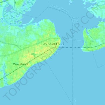
Name: Topografische Karte Bay Saint Louis, Höhe, Relief.
Ort: Bay Saint Louis, Hancock County, Mississippi, United States (30.23938 -89.43455 30.36622 -89.30626)
Durchschnittliche Höhe: 2 m
Minimale Höhe: -3 m
Maximale Höhe: 16 m
USGS topographic maps show a common 25-foot (7.6 m) elevation contour line running throughout a ridge along the former routing of Highway 90 (Old Spanish Trail) on the western edge of the city. As higher ground, this area was spared inundation from the storm surge of Hurricane Katrina.
Andere topografische Karten
Klicken Sie auf eine Karte, um ihre Topografie, ihre Höhe und ihr Relief anzuzeigen.
Pearlington
United States > Mississippi > Hancock County
Pearlington, Hancock County, Mississippi, United States
Durchschnittliche Höhe: 3 m
Diamondhead
United States > Mississippi > Hancock County
Diamondhead, Hancock County, Mississippi, 39525, United States
Durchschnittliche Höhe: 6 m
Kiln
United States > Mississippi > Hancock County > Kiln
Kiln, Hancock County, Mississippi, United States
Durchschnittliche Höhe: 11 m