
Topografische Karte Baltimore
Interaktive Karte
Klicken Sie auf die Karte, um die Höhe anzuzeigen.
Über diese Karte
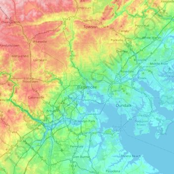
Name: Topografische Karte Baltimore, Höhe, Relief.
Ort: Baltimore, Maryland, 21233, United States (39.13088 -76.77076 39.45088 -76.45076)
Durchschnittliche Höhe: 65 m
Minimale Höhe: -5 m
Maximale Höhe: 219 m
Baltimore is in north-central Maryland on the Patapsco River close to where it empties into the Chesapeake Bay. The city is also located on the fall line between the Piedmont Plateau and the Atlantic coastal plain, which divides Baltimore into "lower city" and "upper city". The city's elevation ranges from sea level at the harbor to 480 feet (150 m) in the northwest corner near Pimlico.
Andere topografische Karten
Klicken Sie auf eine Karte, um ihre Topografie, ihre Höhe und ihr Relief anzuzeigen.
Middle East
United States > Maryland > Baltimore
Middle East, Baltimore, Maryland, United States
Durchschnittliche Höhe: 29 m
Cedarcroft
United States > Maryland > Baltimore
Cedarcroft, Baltimore, Maryland, United States
Durchschnittliche Höhe: 126 m
Broadway East
United States > Maryland > Baltimore
Broadway East, Baltimore, Maryland, United States
Durchschnittliche Höhe: 36 m
Woodberry
United States > Maryland > Baltimore
Woodberry, Baltimore, Maryland, United States
Durchschnittliche Höhe: 94 m
Saint Josephs
United States > Maryland > Baltimore
Saint Josephs, Baltimore, Maryland, United States
Durchschnittliche Höhe: 49 m
Frankford
United States > Maryland > Baltimore
Frankford, Baltimore, Maryland, 21206, United States
Durchschnittliche Höhe: 40 m