
Topografische Karte Woodberry
Interaktive Karte
Klicken Sie auf die Karte, um die Höhe anzuzeigen.
Über diese Karte
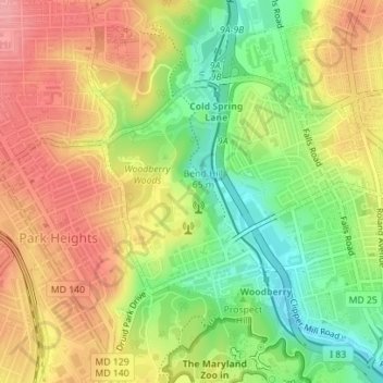
Name: Topografische Karte Woodberry, Höhe, Relief.
Ort: Woodberry, Baltimore, Maryland, United States (39.32956 -76.65823 39.34524 -76.64207)
Durchschnittliche Höhe: 94 m
Minimale Höhe: 40 m
Maximale Höhe: 141 m
Andere topografische Karten
Klicken Sie auf eine Karte, um ihre Topografie, ihre Höhe und ihr Relief anzuzeigen.
Middle East
United States > Maryland > Baltimore
Middle East, Baltimore, Maryland, United States
Durchschnittliche Höhe: 29 m
Baltimore
United States > Maryland > Baltimore
Baltimore, Maryland, 21233, United States
Durchschnittliche Höhe: 65 m
Cedarcroft
United States > Maryland > Baltimore
Cedarcroft, Baltimore, Maryland, United States
Durchschnittliche Höhe: 126 m
Broadway East
United States > Maryland > Baltimore
Broadway East, Baltimore, Maryland, United States
Durchschnittliche Höhe: 36 m
Saint Josephs
United States > Maryland > Baltimore
Saint Josephs, Baltimore, Maryland, United States
Durchschnittliche Höhe: 49 m
Frankford
United States > Maryland > Baltimore
Frankford, Baltimore, Maryland, 21206, United States
Durchschnittliche Höhe: 40 m